Approximate Location Map
Large Map »
Latitude: 52.5338 / 52°32'1"N
Longitude: -2.4129 / 2°24'46"W
OS Eastings: 372087
OS Northings: 292965
OS Grid: SO720929
Mapcode National: GBR BZ.FGP8
Mapcode Global: VH90Z.4K7X
Plus Code: 9C4VGHMP+GR
Entry Name: 15, St Johns Street
Listing Date: 9 March 1970
Grade: II
Source: Historic England
Source ID: 1177984
English Heritage Legacy ID: 254514
ID on this website: 101177984
Location: Low Town, Shropshire, WV15
County: Shropshire
Civil Parish: Bridgnorth
Built-Up Area: Bridgnorth
Traditional County: Shropshire
Lieutenancy Area (Ceremonial County): Shropshire
Church of England Parish: Bridgnorth
Church of England Diocese: Hereford
Tagged with: Building
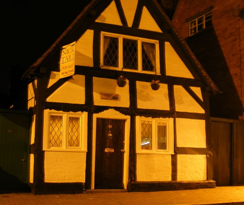
1.
1954 BRIDGNORTH
ST JOHN'S STREET
(Low Town)
(South Side)
No 15
SO 79 SW 3/179 9.3.70.
II GV
2.
Simple C16 black and white timber frame and whitewashed brick cottage.
2 storeys; 1 casement window; simple doorcase; 1 window in moulded wood
architrave on rlght-hand side; gable with plain barge-boards; tiles.
Nos 7, 8, 10, 10A, 11, 15 and 16 form a group
Listing NGR: SO7208792965
External links are from the relevant listing authority and, where applicable, Wikidata. Wikidata IDs may be related buildings as well as this specific building. If you want to add or update a link, you will need to do so by editing the Wikidata entry.


Other nearby listed buildings
