Approximate Location Map
Large Map »
Latitude: 52.5348 / 52°32'5"N
Longitude: -2.4225 / 2°25'21"W
OS Eastings: 371437
OS Northings: 293079
OS Grid: SO714930
Mapcode National: GBR BZ.FD9Y
Mapcode Global: VH83H.YKP5
Plus Code: 9C4VGHMG+WX
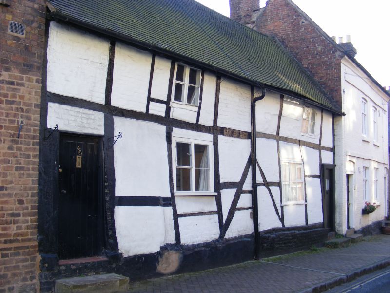
Entry Name: 45 and 46, St Mary's Street
Listing Date: 9 March 1970
Grade: II
Source: Historic England
Source ID: 1295119
English Heritage Legacy ID: 254543
ID on this website: 101295119
Location: Bridgnorth, Shropshire, WV16
County: Shropshire
Civil Parish: Bridgnorth
Built-Up Area: Bridgnorth
Traditional County: Shropshire
Lieutenancy Area (Ceremonial County): Shropshire
Church of England Parish: Bridgnorth
Church of England Diocese: Hereford
Tagged with: Building
This list entry was subject to a Minor Amendment on 13/01/2020
SO 79 SW
2/212
BRIDGNORTH
ST MARY'S STREET (south side)
Nos 45 and 46
9.3.70
GV
II
Late C16 timber frame and painted brick. Single storey plus attic; simple doors and casement windows; sprocket eaves; tiles.
Nos 34 to 46 (consec) form a group
Listing NGR: SO7143793079
External links are from the relevant listing authority and, where applicable, Wikidata. Wikidata IDs may be related buildings as well as this specific building. If you want to add or update a link, you will need to do so by editing the Wikidata entry.


Other nearby listed buildings
