Approximate Location Map
Large Map »
Latitude: 52.6638 / 52°39'49"N
Longitude: -2.3018 / 2°18'6"W
OS Eastings: 379687
OS Northings: 307384
OS Grid: SJ796073
Mapcode National: GBR 06X.T2G
Mapcode Global: WH9DC.M94Q
Plus Code: 9C4VMM7X+G7
Entry Name: The Old Post Office
Listing Date: 26 May 1955
Last Amended: 29 August 1984
Grade: II
Source: Historic England
Source ID: 1307786
English Heritage Legacy ID: 255321
ID on this website: 101307786
Location: Tong, Shropshire, TF11
County: Shropshire
Civil Parish: Tong
Traditional County: Shropshire
Lieutenancy Area (Ceremonial County): Shropshire
Church of England Parish: Tong St Bartholomew
Church of England Diocese: Lichfield
Tagged with: Post office
SJ 70 NE
6/32
TONG CP.
NEWPORT ROAD (north east side),
The Old Post Office
(formerly listed as The Post Office)
26/5/55
GV
II
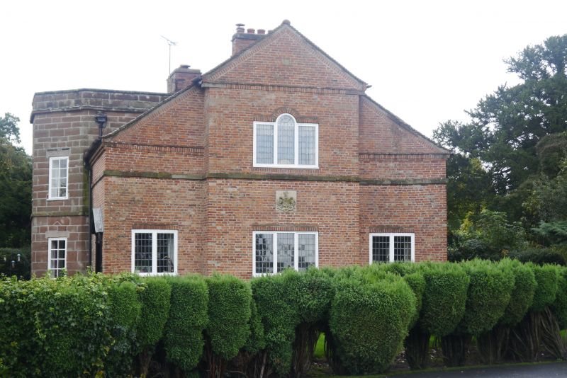
Entrance Lodge, now house. Late C18 or early C19, re-built to south east circa 1946. Squared and coursed sandstone, red brick to south west with stone dressings and old tile roof. Gothick Lodge partly re-built circa 1946 in a Neo-Georgian style. One and a half and two storeys.
Plinth, string course, triangular pedimented gable end to front with raised brick cornice and verge, and two stacks to rear. 1:1:1 bay rhythm; centre bay projecting with small triangular pedimented gable end, and end bays curving outwards. Leaded casements; central first floor three-light window with arched centre light, and two-light ground floor windows flanking central three-light window with carved coat of arms above.
North west front: C20 glazed door to right with Gothick traceried fanlight, and C20 doorcase with reeded pilasters and open triangular pediment; two storey canted bay to left with string course and parapet. Courtyard to rear with battlemented wall.
This was formerly the North Lodge to Tong Castle (qv) and if the now largely demolished Gothic part was late C18 it was probably by 'Capability' Brown.
Included for group value (qv. North gates and gatepiers 30 metres to South-West).
Listing NGR: SJ7968707384
External links are from the relevant listing authority and, where applicable, Wikidata. Wikidata IDs may be related buildings as well as this specific building. If you want to add or update a link, you will need to do so by editing the Wikidata entry.


Other nearby listed buildings
