Approximate Location Map
Large Map »
Latitude: 52.7685 / 52°46'6"N
Longitude: -2.3783 / 2°22'41"W
OS Eastings: 374570
OS Northings: 319052
OS Grid: SJ745190
Mapcode National: GBR 7Z.YQSJ
Mapcode Global: WH9CR.FNPZ
Plus Code: 9C4VQJ9C+9M
Entry Name: 49, High Street
Listing Date: 29 June 1978
Grade: II
Source: Historic England
Source ID: 1177858
English Heritage Legacy ID: 255372
ID on this website: 101177858
Location: Newport, Telford and Wrekin, Shropshire, TF10
County: Telford and Wrekin
Civil Parish: Newport
Built-Up Area: Newport
Traditional County: Shropshire
Lieutenancy Area (Ceremonial County): Shropshire
Church of England Parish: Newport St Nicholas
Church of England Diocese: Lichfield
Tagged with: Building
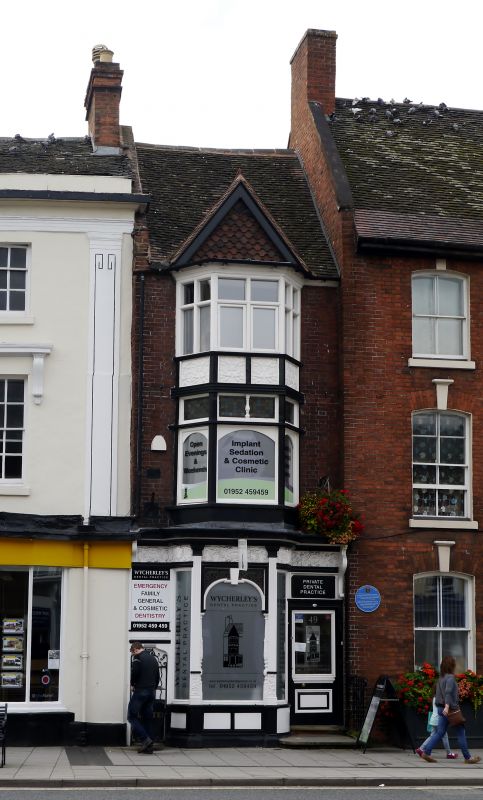
1 HIGH STREET
1.
5362
(West Side)
No 49
SJ 7419 SE 1/78
II GV
2.
C18 and later. Narrow-fronted brick facade; 3 storeys; late C19 splayed bay
window tiered over upper storeys and having tile-hung gable; late C19 splayed
shop front under elaborately moulded cornice and frieze; old tiles. Included
for group value.
Listing NGR: SJ7457019052
External links are from the relevant listing authority and, where applicable, Wikidata. Wikidata IDs may be related buildings as well as this specific building. If you want to add or update a link, you will need to do so by editing the Wikidata entry.


Other nearby listed buildings
