Approximate Location Map
Large Map »
Latitude: 52.7702 / 52°46'12"N
Longitude: -2.381 / 2°22'51"W
OS Eastings: 374394
OS Northings: 319250
OS Grid: SJ743192
Mapcode National: GBR 7Z.YJ6B
Mapcode Global: WH9CR.DMFM
Plus Code: 9C4VQJC9+3J
Entry Name: 121, High Street
Listing Date: 28 April 1952
Grade: II
Source: Historic England
Source ID: 1367286
English Heritage Legacy ID: 255396
ID on this website: 101367286
Location: Newport, Telford and Wrekin, Shropshire, TF10
County: Telford and Wrekin
Civil Parish: Newport
Built-Up Area: Newport
Traditional County: Shropshire
Lieutenancy Area (Ceremonial County): Shropshire
Church of England Parish: Newport St Nicholas
Church of England Diocese: Lichfield
Tagged with: Building
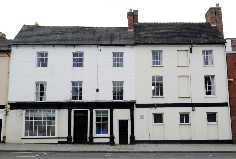
HIGH STREET
1.
5362
(West Side)
No 121
SJ 7419 1/45 28.4.52.
II GV
2.
Early C19 stucco facade to earlier C18 building. 3 storeys; 3 sash windows;
recessed panel at centre of 1st and 2nd storeys; ground storey now altered
with 3 openings, glazed above and blocked below; moulded stucco eaves; tiles.
Listing NGR: SJ7439419250
External links are from the relevant listing authority and, where applicable, Wikidata. Wikidata IDs may be related buildings as well as this specific building. If you want to add or update a link, you will need to do so by editing the Wikidata entry.


Other nearby listed buildings
