Approximate Location Map
Large Map »
Latitude: 52.7695 / 52°46'10"N
Longitude: -2.3785 / 2°22'42"W
OS Eastings: 374559
OS Northings: 319165
OS Grid: SJ745191
Mapcode National: GBR 7Z.YQR1
Mapcode Global: WH9CR.FNM6
Plus Code: 9C4VQJ9C+QH
Entry Name: 14, St Mary Street
Listing Date: 29 June 1978
Grade: II
Source: Historic England
Source ID: 1367293
English Heritage Legacy ID: 255432
ID on this website: 101367293
Location: Newport, Telford and Wrekin, Shropshire, TF10
County: Telford and Wrekin
Civil Parish: Newport
Built-Up Area: Newport
Traditional County: Shropshire
Lieutenancy Area (Ceremonial County): Shropshire
Church of England Parish: Newport St Nicholas
Church of England Diocese: Lichfield
Tagged with: Building
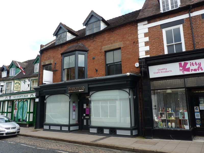
ST MARY STREET
1.
5362
(East Side)
No 14
SJ 7419 SE 1/106
II GV
2.
Late C18 with later alterations. Red brick; 2 storeys plus attic; 3 late
C19 sash windows; quoins at sides; 2 gabled dormers; modern tiles. Late C19
projecting bay shop fronts with modern glazing.
Listing NGR: SJ7455919165
External links are from the relevant listing authority and, where applicable, Wikidata. Wikidata IDs may be related buildings as well as this specific building. If you want to add or update a link, you will need to do so by editing the Wikidata entry.


Other nearby listed buildings
