Approximate Location Map
Large Map »
Latitude: 52.9268 / 52°55'36"N
Longitude: -3.0546 / 3°3'16"W
OS Eastings: 329203
OS Northings: 337119
OS Grid: SJ292371
Mapcode National: GBR 73.MNHR
Mapcode Global: WH89J.1PQM
Plus Code: 9C4RWWGW+P5
Entry Name: Chirkbank Bridge (Bridge Number 21)
Listing Date: 2 September 1987
Grade: II
Source: Historic England
Source ID: 1367369
English Heritage Legacy ID: 255821
ID on this website: 101367369
Location: Chirk Bank, Shropshire, LL14
County: Shropshire
Civil Parish: Weston Rhyn
Built-Up Area: Chirk Bank
Traditional County: Shropshire
Lieutenancy Area (Ceremonial County): Shropshire
Church of England Parish: Weston Rhyn St John
Church of England Diocese: Lichfield
Tagged with: Bridge
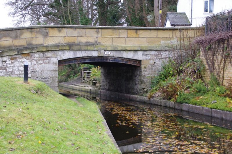
WEST0N RHYN C.P. SHROPSHIRE UNION CANAL
SJ 23 NE
1/107 Chirkbank Bridge
(Bridge No. 21)
II
Canal bridge. Circa 1800 on William Jessop's and Thomas Telford's Ellesmere
Canal. Uncoursed limestone rubble abutments with ashlar string course
and parapet. Cambered arch with stone lintel and projecting keystone has
cast-iron ribs to soffit; retangular corner piers with shallow pyramidal
capping. Cast-iron plate numbered "21" on east side. This section of
the Ellesmere Canal was opended in 1801 to link Chirk with Welsh Frankton.
Charles Hadfield, Canals of the West Midlands (3rd edn. 1985) p.173 A. Black-
wall, Historic Bridges of Shropshire (1985) pp. 58-9.
Listing NGR: SJ2920337119
External links are from the relevant listing authority and, where applicable, Wikidata. Wikidata IDs may be related buildings as well as this specific building. If you want to add or update a link, you will need to do so by editing the Wikidata entry.


Other nearby listed buildings
