Approximate Location Map
Large Map »
Latitude: 52.3796 / 52°22'46"N
Longitude: -3.1176 / 3°7'3"W
OS Eastings: 324023
OS Northings: 276312
OS Grid: SO240763
Mapcode National: GBR B1.R93B
Mapcode Global: VH68Z.XG65
Plus Code: 9C4R9VHJ+RX
Entry Name: Church of St Mary
Listing Date: 21 March 1968
Grade: II
Source: Historic England
Source ID: 1176366
English Heritage Legacy ID: 257312
ID on this website: 101176366
Location: St Mary's Church, Llanfair Waterdine, Shropshire, LD7
County: Shropshire
Civil Parish: Llanfair Waterdine
Traditional County: Shropshire
Lieutenancy Area (Ceremonial County): Shropshire
Church of England Parish: Llanfair Waterdine
Church of England Diocese: Hereford
Tagged with: Church building
LLANFAIR WATERDINE C.P.
SO 27 NW
8/219
LLANFAIR WATERDINE
Church of St Mary
21.3.68
GV
II
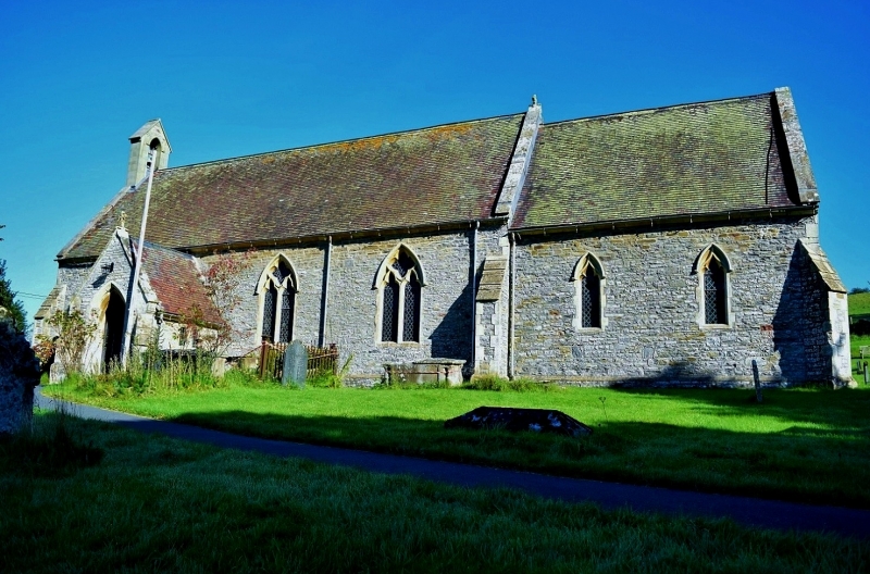
Parish church. 1854 on earlier site, by T. Nicholson. Coursed limestone rubble with ashlar dressings; slate roof. Four bay nave, three bay north aisle, integral north-west tower, south porch, two bay chancel, and north vestry; C14 Gothic style. Plinth; buttresses, diagonal at corners; verge parapets.
Tower: Two stages; string course to battlemented octagonal top stage with ogee-headed bell chamber openings.
Nave: windows with two trefoil-headed lights and returned hoodmoulds; moulded arched doorway in second bay from left with boarded door; gabled porch with chamfered arch, boarded doors, inscribed: "DOMINUS CUSTODET INTROITUM TUUM" above, and side benches within; west window with two trefoil-headed lights and Y-tracery.
North aisle: paired ogee-headed lights.
Chancel: ogee-headed lancets with returned hoodmoulds; east window with three trefoiled ogee-headed lights, trefoiled tracery, and returned hoodmould.
Interior: single framed roofs with braced collars and crested wall plates; four bay north aisle arcade with octagonal piers, moulded bases and capitals, and double chamfered arches; double chamfered chancel arch, dying into responds; C19 octagonal stone font with wooden cover; communion rails made up from parts of late mediaeval screen carved with foliage including vines and grapes, figures, lions, dragons, and inscription; pews with the names of farms in the parish painted on; circa 1620 communion table.
The former spire was demolished in 1975.
This entry was subject to a Minor Amendment on 1 November 2016.
External links are from the relevant listing authority and, where applicable, Wikidata. Wikidata IDs may be related buildings as well as this specific building. If you want to add or update a link, you will need to do so by editing the Wikidata entry.


Other nearby listed buildings
