Approximate Location Map
Large Map »
Latitude: 52.6572 / 52°39'25"N
Longitude: -2.6952 / 2°41'42"W
OS Eastings: 353068
OS Northings: 306831
OS Grid: SJ530068
Mapcode National: GBR BL.5R4X
Mapcode Global: WH8C1.KGRS
Plus Code: 9C4VM843+VW
Entry Name: Barn approximately 25 metres to north of Manor Farmhouse
Listing Date: 14 May 1986
Grade: II
Source: Historic England
Source ID: 1177101
English Heritage Legacy ID: 259699
ID on this website: 101177101
Location: Berrington, Shropshire, SY5
County: Shropshire
Civil Parish: Berrington
Traditional County: Shropshire
Lieutenancy Area (Ceremonial County): Shropshire
Church of England Parish: Berrington with Betton Strange
Church of England Diocese: Hereford
Tagged with: Barn
SJ 5206-5306
11/46
BERRINGTON CP
BERRINGTON
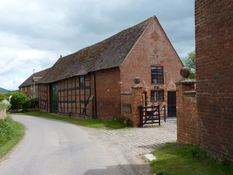
Barn approximately 25 metres to north of Manor Farmhouse
GV
II
Barn. Mid C17 with mid-to late C19 addition. Timber-framed with red brick nogging and addition; plain tile roof. Four framed bays; opposed waggon entries in second bay from east and addition to west. Dentil brick eaves cornice to late C19 part.
Framing: square panels, three large panels from sole plate to wall plate with probably later division into smaller rectangular panels; long straight tension braces. North front: boarded loft door to right and pair of large boarded doors to left; right-hand gable end: segmental-headed boarded loft door, central ground-floor two-light segmental-headed window flanked by two segmental-headed boarded doors; lozenge shaped vents in gable above.
INTERIOR: roof with pairs of purlins; cross-frames with sole plates on low walls, central posts up to tie beams, long straight tension braces and short corner braces, trusses with cambered tie beams and raking queen struts, and collar and tie-beam end trusses with queen struts.
This is notable as a complete example of a C17 barn and it occupies a prominent position in the village near Manor Farmhouse (q.v.) and the Church of All Saints (q.v.).
Listing NGR: SJ5306706831
External links are from the relevant listing authority and, where applicable, Wikidata. Wikidata IDs may be related buildings as well as this specific building. If you want to add or update a link, you will need to do so by editing the Wikidata entry.


Other nearby listed buildings
