Approximate Location Map
Large Map »
Latitude: 52.8552 / 52°51'18"N
Longitude: -2.7267 / 2°43'36"W
OS Eastings: 351165
OS Northings: 328882
OS Grid: SJ511288
Mapcode National: GBR 7J.S46G
Mapcode Global: WH8B2.2HVH
Plus Code: 9C4VV74F+38
Entry Name: 69, High Street
Listing Date: 6 June 1983
Grade: II
Source: Historic England
Source ID: 1055477
English Heritage Legacy ID: 259944
ID on this website: 101055477
Location: Wem, Shropshire, SY4
County: Shropshire
Civil Parish: Wem Urban
Built-Up Area: Wem
Traditional County: Shropshire
Lieutenancy Area (Ceremonial County): Shropshire
Church of England Parish: Wem St Peter and St Paul
Church of England Diocese: Lichfield
Tagged with: Building
1.
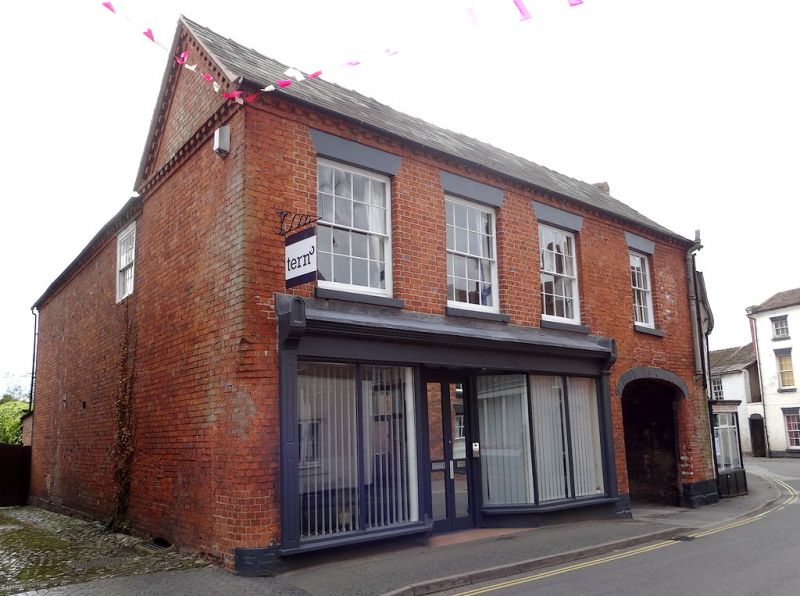
5358 HIGH STREET
(south side)
No 69
SJ 5128 3/39
II GV
2.
Early/mid C19 red brick range. Welsh slate roof with pedimented gable ends and
brick dentil eaves. Two storeys. Four bays. Sash windows with glazing bars and
plain lintels. Right hand elliptical arched carriageway. Remainder of ground floor
taken up by Victorian shop front with pilasters and cornice.
Listing NGR: SJ5116528882
External links are from the relevant listing authority and, where applicable, Wikidata. Wikidata IDs may be related buildings as well as this specific building. If you want to add or update a link, you will need to do so by editing the Wikidata entry.


Other nearby listed buildings
