Approximate Location Map
Large Map »
Latitude: 52.8549 / 52°51'17"N
Longitude: -2.7277 / 2°43'39"W
OS Eastings: 351095
OS Northings: 328847
OS Grid: SJ510288
Mapcode National: GBR 7J.S3YL
Mapcode Global: WH8B2.2HCQ
Plus Code: 9C4VV73C+XW
Entry Name: Astbury House
Listing Date: 6 June 1983
Grade: II
Source: Historic England
Source ID: 1055435
English Heritage Legacy ID: 259948
ID on this website: 101055435
Location: Wem, Shropshire, SY4
County: Shropshire
Civil Parish: Wem Urban
Built-Up Area: Wem
Traditional County: Shropshire
Lieutenancy Area (Ceremonial County): Shropshire
Church of England Parish: Wem St Peter and St Paul
Church of England Diocese: Lichfield
Tagged with: House
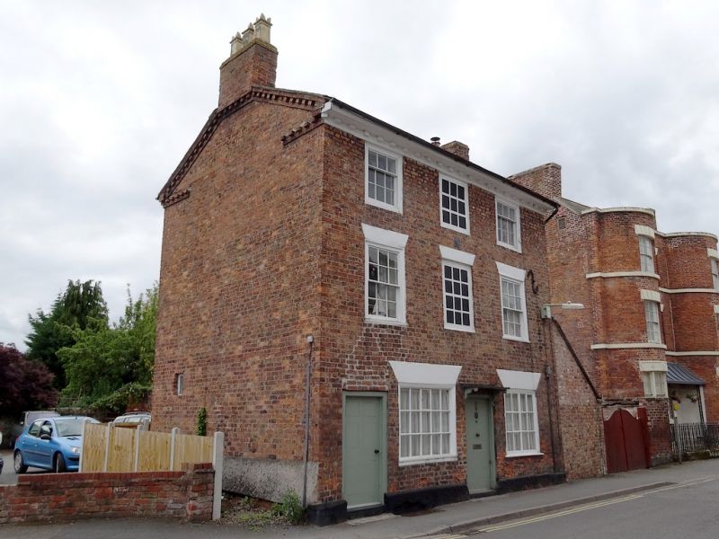
1.
5358 HIGH STREW
(south side)
No 89
(Astbury House)
SJ 5128 3/43
II GV
2.
Small late C18 brick house. Slate roof with pedimental gable ends and brick dentil
eaves. Three storeys. Three bays. Sashes with glazing bars in exposed moulded
casing and with stuccoed heads. Ground floor 2 small multi-pane shop windows in
moulded frames. Two flush panel doors with hoods on brackets. Fire insurance plaque
on front.
Listing NGR: SJ5109528847
External links are from the relevant listing authority and, where applicable, Wikidata. Wikidata IDs may be related buildings as well as this specific building. If you want to add or update a link, you will need to do so by editing the Wikidata entry.


Other nearby listed buildings
