Approximate Location Map
Large Map »
Latitude: 52.9695 / 52°58'10"N
Longitude: -2.6788 / 2°40'43"W
OS Eastings: 354509
OS Northings: 341566
OS Grid: SJ545415
Mapcode National: GBR 7L.JXFY
Mapcode Global: WH89H.TMKC
Plus Code: 9C4VX89C+RF
Entry Name: Churton Memorial Drinking Fountain
Listing Date: 1 March 1988
Grade: II
Source: Historic England
Source ID: 1307452
English Heritage Legacy ID: 260592
ID on this website: 101307452
Location: Whitchurch, Shropshire, SY13
County: Shropshire
Civil Parish: Whitchurch Urban
Built-Up Area: Whitchurch
Traditional County: Shropshire
Lieutenancy Area (Ceremonial County): Shropshire
Church of England Parish: Whitchurch St Alkmund
Church of England Diocese: Lichfield
Tagged with: Drinking fountain
WHITCHURCH URBAN C.P. BROWNLOW STREET (west
SJ 5441
SJ 54508 41565 side)
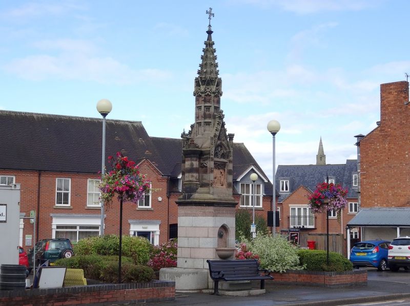
8/39 Churton Memorial
- Drinking Fountain
GV II
Drinking fountain, Dated 1882. Banded pink and grey granite base and banded
red and grey sandstone ashlar upper parts. Octagonal plan. In a Gothic
Revival style. Base with moulded stone cornice, steps up to chamfered-
arched recess to front and back with copper lion-mask spouts and semi-circular
bowls, and former semi-circular animal troughs to each side (flower beds at
time of survey - November 1986). Inscription around top: "EVERY : ONE :
THAT : DRINKETH / OF : THIS : WATER / SHALL THIRST : AGAIN / BUT :
WHOSOEVER / DRINKETH : OF : THE : WATER : THAT / I : SHALL : GIVE : HIM /
SHALL : NEVER : THIRST / ST JOHN : CHAP 4: VER 13 & 14". Chamfered
offset to top part. Moulded arches to front and back, each with 2 cinquefoil-
headed lights (but no central shaft), blind tracery, flanking square buttress
with battlemented caps, and crocketed gable above with finial. Each side with
2 cinquefoil-headed blind panels, octagonal pier with moulded base and
cap, and disused gas-lamp fitting. Octagonal pinnacle above consisting
of blind ogee trefoil-headed panels to sides with gables above, and short
crocketed spire with wrought-iron cross finial. Carved panel in arch to east
depicting 2 women drawing water from a well. Inscription in arch to west
not completely legible at time of survey (November 1986): THIS FOUNTAIN WAS/
ERECTED BY JOHN CHURTON / OF ... / IN LOVING MEMORY OF / HIS PARENTS AND...
WIFE / ANN CHURTON AND AS / A MEMORIAL OF HIS / AFFECTIONATE & ENDURING /
INTEREST IN THE WELFARE / OF HIS NATIVE TOWN 1882". The fountain formerly
stood at the junction of Green End, Brownlow Street, Talbot Street and
Station Road, but when the by-pass was built in 1924 it became a hindrance
to traffic, and was eventually moved to its present site in the early 1930's.
Whitchurch Area Archaeological Group, Whitchurch Remembered (1979), ill.71.
Listing NGR: SJ5450941566
External links are from the relevant listing authority and, where applicable, Wikidata. Wikidata IDs may be related buildings as well as this specific building. If you want to add or update a link, you will need to do so by editing the Wikidata entry.


Other nearby listed buildings
