Approximate Location Map
Large Map »
Latitude: 52.967 / 52°58'1"N
Longitude: -2.682 / 2°40'55"W
OS Eastings: 354288
OS Northings: 341291
OS Grid: SJ542412
Mapcode National: GBR 7L.K30N
Mapcode Global: WH89H.SP08
Plus Code: 9C4VX889+R5
Entry Name: 17, Dodington
Listing Date: 1 May 1951
Grade: II
Source: Historic England
Source ID: 1307322
English Heritage Legacy ID: 260612
ID on this website: 101307322
Location: Whitchurch, Shropshire, SY13
County: Shropshire
Civil Parish: Whitchurch Urban
Built-Up Area: Whitchurch
Traditional County: Shropshire
Lieutenancy Area (Ceremonial County): Shropshire
Church of England Parish: Whitchurch St Alkmund
Church of England Diocese: Lichfield
Tagged with: Building
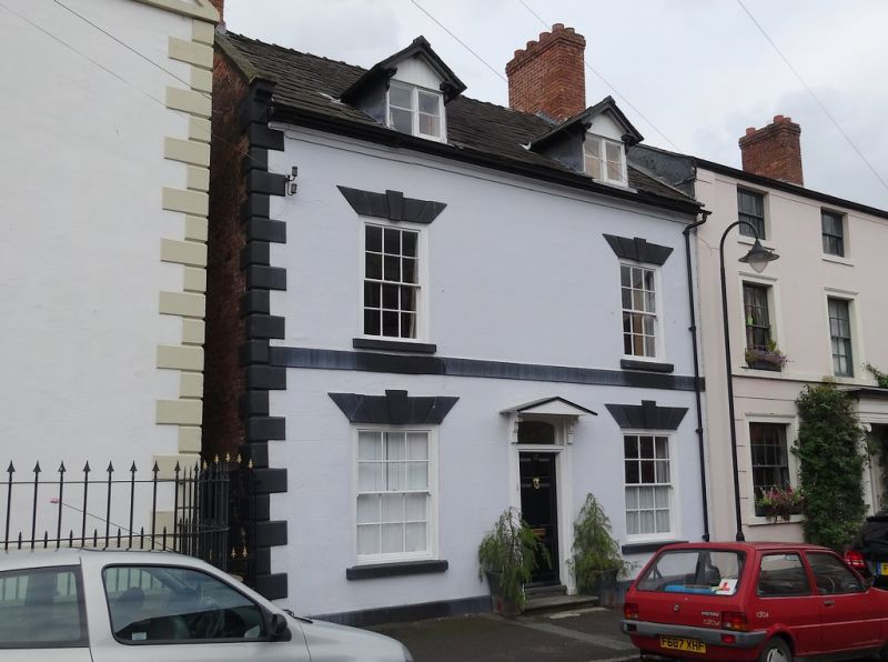
SJ 5441
8/58
1.5.51
WHITCHURCH URBAN C.P.
DODINGTON (south-west side)
No. 17
GV
II
House. Mid-C18, possibly incorporating some earlier fabric. Remodelled in
the early C19. Red brick with some painted stone dressings, rendered and
lined as ashlar to front. Possibly incorporating an earlier timber framed
core. Graded slate roof. 2 storeys and attic. Plinth, chamfered quoins,
plat band, moulded stone eaves cornice, and parapeted gable end to left with
stone coping and shaped stone kneeler. Integral brick end stack to left
and external brick end stack to right [shared with No. 15 (q.v.)]. Pair of
small C19 gabled eaves dormers with 2-light wooden casements. 2-window
front; boxed glazing bar sashes with painted stone cills and rusticated
lintels with raised keystones. Central C20 door with 6 raised and fielded
panels and early C19 surround consisting of beaded frame, segmental-headed
overlight, architrave, and small shaped brackets supporting triangular-
pedimented hood. Left-hand gable end with small 2-light attic window.
Interior not inspected but owner reports (November 1986) timber framed
partition walls (C18 or possibly earlier), and C18 dog-leg staircase with
turned balusters.
Listing NGR: SJ5428841291
External links are from the relevant listing authority and, where applicable, Wikidata. Wikidata IDs may be related buildings as well as this specific building. If you want to add or update a link, you will need to do so by editing the Wikidata entry.


Other nearby listed buildings
