Approximate Location Map
Large Map »
Latitude: 52.9696 / 52°58'10"N
Longitude: -2.6841 / 2°41'2"W
OS Eastings: 354156
OS Northings: 341583
OS Grid: SJ541415
Mapcode National: GBR 7L.JVZN
Mapcode Global: WH89H.RM28
Plus Code: 9C4VX898+V9
Entry Name: 25, High Street
Listing Date: 1 May 1951
Last Amended: 1 March 1988
Grade: II
Source: Historic England
Source ID: 1055984
English Heritage Legacy ID: 260646
ID on this website: 101055984
Location: Whitchurch, Shropshire, SY13
County: Shropshire
Civil Parish: Whitchurch Urban
Built-Up Area: Whitchurch
Traditional County: Shropshire
Lieutenancy Area (Ceremonial County): Shropshire
Church of England Parish: Whitchurch St Alkmund
Church of England Diocese: Lichfield
Tagged with: Building
SJ 5441
8/90
1.5.51
WHITCHURCH URBAN C.P.
HIGH STREET (north-east side)
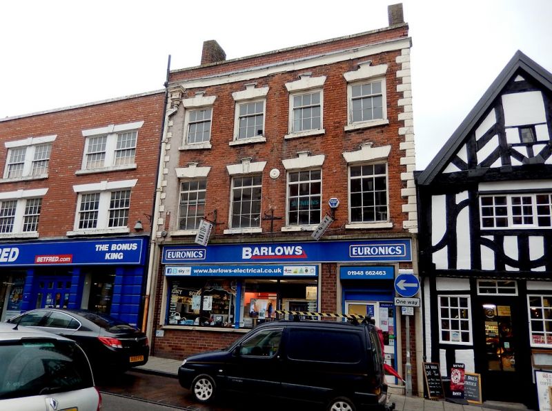
No. 25 (formerly listed as Lloyd's Bank)
GV
II
House, now bank. Dated 1753 (rainwater head). Ground floor altered
in early C20 and c.1950. Red brick with painted stone dressings. Roof
with C20 concrete tiles. 3 storeys. Chamfered quoins, frieze and
moulded cornice, and parapet with coping. Integral brick end stacks.
4 bays; glazing bar sashes (first floor with C20 imitations) with
painted stone cills and painted stone lintels with rustication and raised
keystones with moulded tops. Ground floor of c.1950 with plate-glass
window and pair of panelled doors to right. Cast square-section rainwater
head to left with festoon and moulded top; cast square section downpipe.
The rainwater head downpipe were formerly placed in the centre of the
facade (see mark on brickwork). Interior altered in early C20: 2-storey
banking hall with frieze and moulded cornice, and central beam with 2
round arches above.
Listing NGR: SJ5415641583
External links are from the relevant listing authority and, where applicable, Wikidata. Wikidata IDs may be related buildings as well as this specific building. If you want to add or update a link, you will need to do so by editing the Wikidata entry.


Other nearby listed buildings
