Approximate Location Map
Large Map »
Latitude: 50.9422 / 50°56'31"N
Longitude: -2.633 / 2°37'58"W
OS Eastings: 355619
OS Northings: 116050
OS Grid: ST556160
Mapcode National: GBR MP.NSVS
Mapcode Global: FRA 56CM.B09
Plus Code: 9C2VW9R8+VQ
Entry Name: St Johns Schoolrooms
Listing Date: 27 October 1982
Grade: II
Source: Historic England
Source ID: 1055717
English Heritage Legacy ID: 261348
ID on this website: 101055717
Location: Yeovil, Somerset, BA20
County: Somerset
District: South Somerset
Civil Parish: Yeovil
Built-Up Area: Yeovil
Traditional County: Somerset
Lieutenancy Area (Ceremonial County): Somerset
Tagged with: Building School building
ST5516SE YEOVIL CP CHURCH STREET (North side)
5/11 St Johns Schoolrooms
27.10.82
GV II
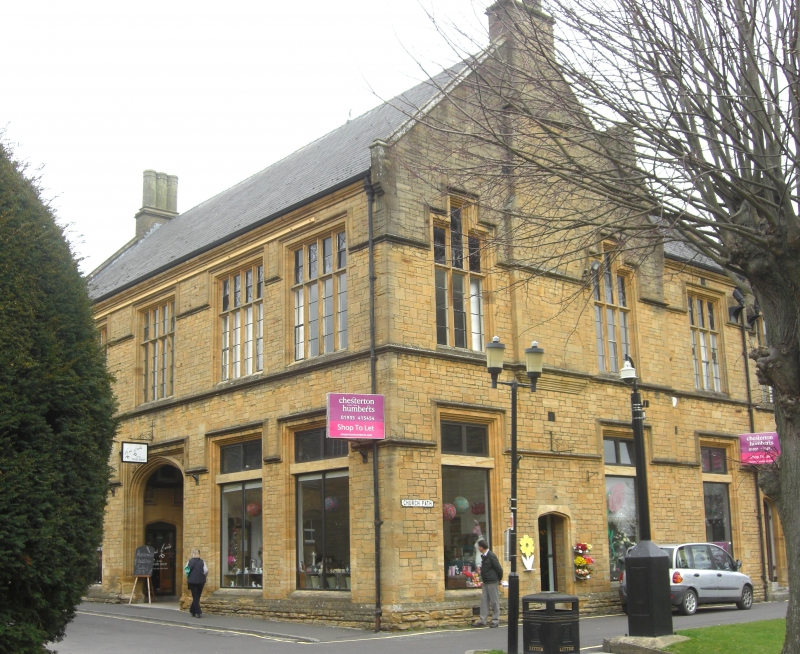
Schoolrooms erected 1816/7. Ham stone ashlar in a Quasi-collegiate manner, Welsh
slated roof between coped gables, each gable crowned by short stone chimney
stack. 2-storey 5-bay facade to Church Street, with a big arched recessed porch
in Tudor style centrally with steps up, and plinth all around; tall 4-light
mullioned and transomed windows with flat heads and linked label moulds at both
levels, with string course to first floor cill level and stone eaves moulding.
On the return Church Path elevation are the main gable, a short extension and a
smaller gable: the main gable has corbelled projecting chimney stack as main
feature, flanked by matching 3-light mullioned and transomed windows at each
level, the centre light of the first floor windows being raised; the windows are
repeated in the one-bay extension and second gable (first floor only), beneath
this last pair of pointed arched entrance doorways: above and between them a
good oblong sculptured panel. The interior not seen. Erected to replace the
earlier (1618) Sunday Schools which stood in Vicarage Street, and incorporating
the Chantry (q.v.).
Listing NGR: ST5561916050
External links are from the relevant listing authority and, where applicable, Wikidata. Wikidata IDs may be related buildings as well as this specific building. If you want to add or update a link, you will need to do so by editing the Wikidata entry.


Other nearby listed buildings
