Approximate Location Map
Large Map »
Latitude: 50.9434 / 50°56'36"N
Longitude: -2.6652 / 2°39'54"W
OS Eastings: 353364
OS Northings: 116201
OS Grid: ST533162
Mapcode National: GBR MM.NYD5
Mapcode Global: FRA 569M.3J6
Plus Code: 9C2VW8VM+8W
Entry Name: Higher Preston Farm House
Listing Date: 17 October 1983
Grade: II
Source: Historic England
Source ID: 1056511
English Heritage Legacy ID: 261403
ID on this website: 101056511
Location: Preston Plucknett, Somerset, BA20
County: Somerset
District: South Somerset
Civil Parish: Yeovil
Built-Up Area: Yeovil
Traditional County: Somerset
Lieutenancy Area (Ceremonial County): Somerset
Tagged with: Farmhouse
ST51NW YEOVIL CP PRESTON ROAD (South side)
1/65 Higher Preston Farm House
-
- II
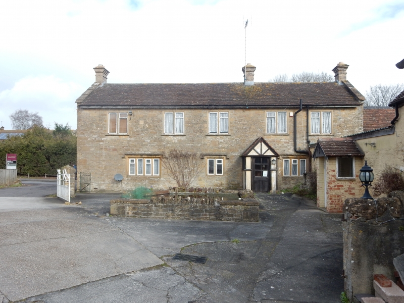
Farmhouse, built 1649, but subsequently modified; Ham Stone, random coursed with
fine face; plain Clay tile roof between coped gables, 2 end chimneys and one uff
centre rebuilt in brick. Main South facade has irregular fenestration.
2-storeys, with one 4-light stone mullioned window with ovolo mouldings and
label over, off-centre door (relocated) and on right-hand two 2-light mullioned
windows with hollow chamfers; on first floor 5-C20 double windows. On North
(street) facade two 3-light and one 4-light stone mullioned windows with large
rectangular leaded panes, hollow chamfer moulded with labels over; at first
floor level two 3-light wooden casements, one with ovolo mouldings, both with
leaded panes. Interior not inspected, but Sir R Hall refers to lintol in kitchen
fireplace dated 1649, and to elm ceiling beams with scroll stops to chamfers.
The lean-to on the East side and all outbuildings of little interest. (Hall, Sir
R. De Z. 'Post Medieval Land Tenure, Preston Plucknett' 1961 S.A.N.H.S.
Proceedings Vol. 105).
Listing NGR: ST5336416201
External links are from the relevant listing authority and, where applicable, Wikidata. Wikidata IDs may be related buildings as well as this specific building. If you want to add or update a link, you will need to do so by editing the Wikidata entry.


Other nearby listed buildings
