Approximate Location Map
Large Map »
Latitude: 51.0901 / 51°5'24"N
Longitude: -2.513 / 2°30'46"W
OS Eastings: 364166
OS Northings: 132438
OS Grid: ST641324
Mapcode National: GBR MV.CM3F
Mapcode Global: FRA 56M7.NSF
Plus Code: 9C3V3FRP+3Q
Entry Name: National Westminster Bank
Listing Date: 18 March 1986
Grade: II
Source: Historic England
Source ID: 1177487
English Heritage Legacy ID: 262008
ID on this website: 101177487
Location: Castle Cary, Somerset, BA7
County: Somerset
District: South Somerset
Civil Parish: Castle Cary
Built-Up Area: Castle Cary
Traditional County: Somerset
Lieutenancy Area (Ceremonial County): Somerset
Tagged with: Bank building
ST6432
6/75
CASTLE CARY CP
HIGH STREET (North side)
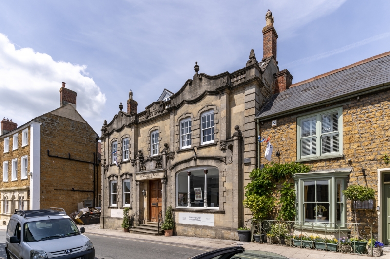
National Westminster Bank
GV II
Bank. Circa 1900. Doulting stone ashlar; Welsh slate roof between stepped coped gables;
brick chimney stacks. Art Nouveau style; 2 storeys with attics; 3 bays, of which the two
outer bays project slightly. Plinth, rusticated quoins, interrupted cornice and
balustrade; sash windows of 12 panes, in pairs to outer bays set in rusticated elliptical
arched surrounds with swan-neck hoods, more pronounced at lower level; glazing bars
removed from lower bay 1; bay 3 has a larger 3-unit display, the window having
elaborately carved timber mullions; central pitched roof dormer window; the bay 2
doorway, up 4 steps, has large 3-panelled doors set in a surround which spans between
the outer bay projections and has flanking pilasters with Byzantine caps; plain flat
hood with swan-neck balustrade over with bell-capped end piers, matched by similar piers
on corners; in shaped centre panel of parapet a monogram of S.B.Co and 'Estd 1826' - this
was Stuckeys Bank, originating in Langport, which had branches throughout Somerset until,
after various C20 mergers, it became part of National Westminster Bank. Interior not
seen. Imposing facade, included primarily for its streetscape value, especially in
relation to the Market Place.
Listing NGR: ST6416632438
External links are from the relevant listing authority and, where applicable, Wikidata. Wikidata IDs may be related buildings as well as this specific building. If you want to add or update a link, you will need to do so by editing the Wikidata entry.


Other nearby listed buildings
