Approximate Location Map
Large Map »
Latitude: 50.9096 / 50°54'34"N
Longitude: -2.8278 / 2°49'39"W
OS Eastings: 341898
OS Northings: 112567
OS Grid: ST418125
Mapcode National: GBR MD.QZB9
Mapcode Global: FRA 46ZP.S6K
Plus Code: 9C2VW55C+VV
Entry Name: The Old Farmhouse
Listing Date: 4 February 1958
Grade: II
Source: Historic England
Source ID: 1056099
English Heritage Legacy ID: 262338
ID on this website: 101056099
Location: Hinton St George, Somerset, TA17
County: Somerset
District: South Somerset
Civil Parish: Hinton St. George
Built-Up Area: Hinton St George
Traditional County: Somerset
Lieutenancy Area (Ceremonial County): Somerset
Church of England Parish: Hinton St George with Dinnington
Church of England Diocese: Bath and Wells
Tagged with: Farmhouse Thatched farmhouse
ST4112 HINTON ST GEORGE CP WEST STREET (South side)
7/88 The Old Farmhouse
4.2.38
GV II
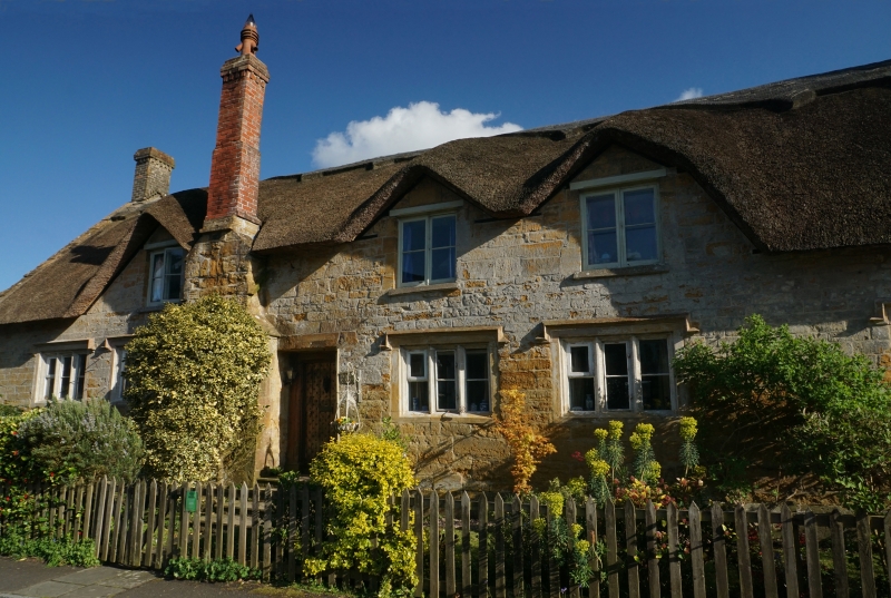
Semi-detached farmhouse. Possibly C16, altered in C17 and C18. Ham stone roughly cut and squared, ashlar dressings;
thatched roof with stepped coped gable to east, continuation to west; brick chimney stacks. Single-storey with attics,
6 bays. Hollow-chamfer mullioned windows in chamfered recesses with labels, all 3-light. Attic windows of 2-light
horizontal-bar casements set into thatch, bays 2, 4 and 5. Boarded door set in heavy frame, beaded and slightly
camfered, in bay 3, in a recess up 3 steps. Between bays 2/3 a projecting chimney breast with band course and double
offsets. Blocked window at front of east gable, later casement windows towards rear. Interior not seen, but reported is
a 3-room cross passage plan; hall has a chamfered-arched fireplace in north wall; parlour has a shell-hood recess in
position of blocked window; 3rd room has stud and panelled partition. Most beams cased, but one deep chamfered with
step and runout stop, another shallow-chamfered with cyna-recta stop: remains of jointed cruck built into wall near
west gable, still visible in roof, although roof frame raised at some stage, (Attached to west gable is Cobbles (qv)).
(VAG Report, unpublished SRO, 1973).
Listing NGR: ST4189812567
External links are from the relevant listing authority and, where applicable, Wikidata. Wikidata IDs may be related buildings as well as this specific building. If you want to add or update a link, you will need to do so by editing the Wikidata entry.


Other nearby listed buildings
