Approximate Location Map
Large Map »
Latitude: 50.8699 / 50°52'11"N
Longitude: -2.8383 / 2°50'17"W
OS Eastings: 341107
OS Northings: 108154
OS Grid: ST411081
Mapcode National: GBR MD.TGRQ
Mapcode Global: FRA 46YS.VFP
Plus Code: 9C2VV596+XM
Entry Name: Woolminstone Farmhouse
Listing Date: 4 February 1958
Grade: II
Source: Historic England
Source ID: 1175997
English Heritage Legacy ID: 262471
ID on this website: 101175997
Location: Woolminstone, Somerset, TA18
County: Somerset
District: South Somerset
Civil Parish: West Crewkerne
Traditional County: Somerset
Lieutenancy Area (Ceremonial County): Somerset
Church of England Parish: Crewkerne
Church of England Diocese: Bath and Wells
Tagged with: Farmhouse
ST40NW
5/212
WEST CREWKERNE CP
WOOLMINSTONE
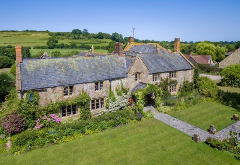
Woolminstone Farmhouse
4.2.58
II
Detached farmhouse. C17, one section dated 1617. Ham stone roughly cut and squared, ashlar dressings; Welsh slate roof between high stepped gables replacing thatch, hipped on angle; brick chimney stacks.
L- plan with additions; two storey with attic, five bay south elevation. Hollow-chamfer mullioned windows in wave-mould recesses, all three-light except first floor bays one, two and three which are two-light, the lower windows with labels. Six-panelled door to lower bay three, originally protected by open porch with room over, removed early in C20, with the upper bay three window reset under a gable, and the supporting columns, square rusticated ashlar, remain supporting a Welsh slated single storey porch roof. East gable and flant of three bays, having hollow-chamfered mullioned windows in chamfered recesses, the first floor bay three window extended, and the bay windows of four lights, the upper leaded, all with labels. In the gable, bay one, a chamfered recessed doorway without label, with 'I.D.1617' incised on lintel and plaque with arms of Merifield above - both may be relocations. Further mullioned windows to rear, some C17 and some C17, the north gable having pairs to each level including attic, some blocked. Interior not seen.
Listing NGR: ST4110708154
External links are from the relevant listing authority and, where applicable, Wikidata. Wikidata IDs may be related buildings as well as this specific building. If you want to add or update a link, you will need to do so by editing the Wikidata entry.


Other nearby listed buildings
