Approximate Location Map
Large Map »
Latitude: 51.0536 / 51°3'13"N
Longitude: -2.7318 / 2°43'54"W
OS Eastings: 348801
OS Northings: 128510
OS Grid: ST488285
Mapcode National: GBR MJ.FZPD
Mapcode Global: FRA 565B.FK2
Plus Code: 9C3V3739+F7
Entry Name: The Hext Almshouses
Listing Date: 17 April 1959
Last Amended: 30 September 1985
Grade: II*
Source: Historic England
Source ID: 1295258
English Heritage Legacy ID: 263063
ID on this website: 101295258
Location: Somerton, Somerset, TA11
County: Somerset
District: South Somerset
Civil Parish: Somerton
Built-Up Area: Somerton
Traditional County: Somerset
Lieutenancy Area (Ceremonial County): Somerset
Tagged with: Almshouse
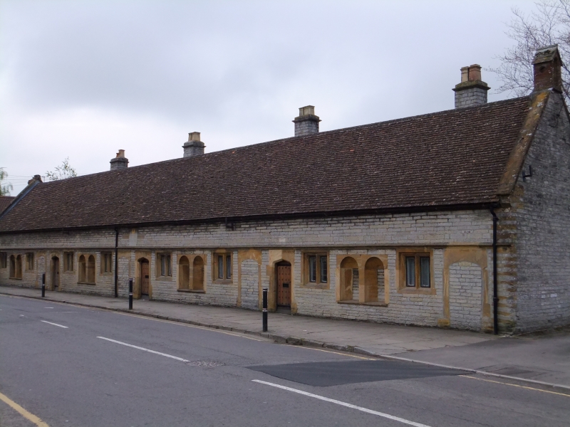
ST4828 SOMERTON CP WEST STREET (South side)
8/255 The Hext Almshouses
(formerly listed as Almshouses)
17.4.59
GV II*
Almshouses. Dated 1626 remodelled 1883 and 1967. Local lias stone cut and squared with Ham stone dressings; undulating
plain clay tile roof between coped gables having gabletted finial at east end and small stone bell turret, without
bell, to west; brick and stone chimney stacks to rear. Single storey 8 bays, formerly one bay to each house, but now
modified; each bay has a boarded and studded door in chamfered cambered archway, then a 2-light hollow chamfer
mullioned window, then semi-circular arched niche seats for the occupants, appearing in pairs as alternate bays were
handed; all right hand (even number bays) doors now blocked: continuous string over all openings; in centre stone
plaque with painted arms inscribed 'E.H/He hath Dispersed/abroad and Given/to the Poor/His Benevolence/Remaineth for
ever/1626", flanked by 1967 tablets recording latest restoration. Interior not seen. Started by Sir Edward Hext before
he died in 1624 and intended for 8 men; this was reduced to 4 in 1883 when the premises were remodelled. (VCH, Volume
III, 1974).
Listing NGR: ST4880128510
External links are from the relevant listing authority and, where applicable, Wikidata. Wikidata IDs may be related buildings as well as this specific building. If you want to add or update a link, you will need to do so by editing the Wikidata entry.


Other nearby listed buildings
