Approximate Location Map
Large Map »
Latitude: 50.95 / 50°56'59"N
Longitude: -2.7224 / 2°43'20"W
OS Eastings: 349348
OS Northings: 116977
OS Grid: ST493169
Mapcode National: GBR MK.NG2K
Mapcode Global: FRA 565L.R5R
Plus Code: 9C2VW7XH+X2
Entry Name: Tower on St Michaels Hill
Listing Date: 19 April 1961
Grade: II
Source: Historic England
Source ID: 1057255
English Heritage Legacy ID: 263542
ID on this website: 101057255
Location: Montacute, Somerset, TA15
County: Somerset
District: South Somerset
Civil Parish: Montacute
Built-Up Area: Montacute
Traditional County: Somerset
Lieutenancy Area (Ceremonial County): Somerset
Tagged with: Building
ST4614 MONTACUTE CP
8/87 Tower on St. Michaels Hill
19.4.61
- II
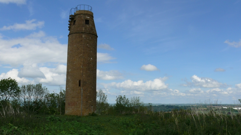
Folly, used as signal tower. 1760. Ham stone ashlar, flat stone top. Circular on plan, about 3m diameter, and about 12m
tall: chamfered flat- arched doorway on east side, and 3 slit-light windows at various levels on north-west, south and
south-east sectors, illuminating the internal newel stone staircase; at the crown there is a string course, above which
the walls have a marked batter into the flat top: on the east face above the string is a cantilevered platform with
doorway at head of stairs, and an external stair to the flat top, without any surviving guard rails. There is a Greek
inscription over the doorway and the initials 'K.P. 1760' (but Edward Phelips was the likely builder). The hill was the
site of a Norman Castle, mostly demolished to build the Priory of Montacute: St. Michael's Chapel, first recorded 1102,
survived at least until the mid C17; its site now occupied by the tower, which was used as a signal tower to Swayne
Harbin at Newton Surmaville (using the Round House, Item 2/26 Barwick C.P., q.v) and Mr. Goodford, of Chilton Cantelo.
Scheduled Ancient Monument (Somerset County No 101). (Nares S, Country Life, 5th September, 1952, p679).
Listing NGR: ST4934816977
External links are from the relevant listing authority and, where applicable, Wikidata. Wikidata IDs may be related buildings as well as this specific building. If you want to add or update a link, you will need to do so by editing the Wikidata entry.


Other nearby listed buildings
