Approximate Location Map
Large Map »
Latitude: 51.1852 / 51°11'6"N
Longitude: -3.4445 / 3°26'40"W
OS Eastings: 299140
OS Northings: 143877
OS Grid: SS991438
Mapcode National: GBR LK.5R5M
Mapcode Global: VH6GM.7GWS
Plus Code: 9C3R5HP4+36
Entry Name: Tamarisk
Listing Date: 4 August 1983
Grade: II
Source: Historic England
Source ID: 1345587
English Heritage Legacy ID: 264633
ID on this website: 101345587
Location: Dunster, Somerset, TA24
County: Somerset
District: Somerset West and Taunton
Civil Parish: Dunster
Built-Up Area: Dunster
Traditional County: Somerset
Lieutenancy Area (Ceremonial County): Somerset
Tagged with: Building
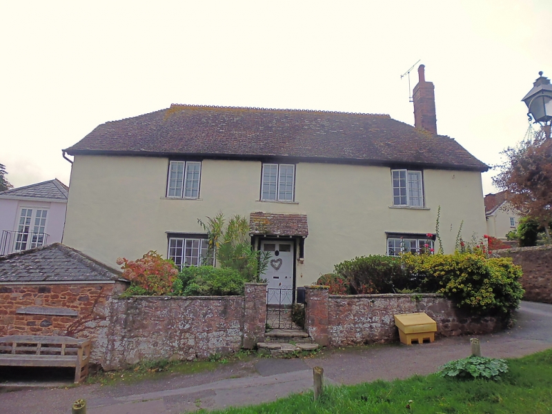
1.
5366 DUNSTER THE BALL
No 2 (Tamarisk)
SS 9843-9943 4/2
II GV
2.
Late 18th century or early 19th century. Colourwashed render. Half-hipped plain
tile roof, brick chimney stack. Two storeys. Five windows, 2-light wooden casements
to first floor, 3-light wooden casements to ground floor, glazing bars. Central
panelled door, later tiled hood on brackets. included for group value.
Listing NGR: SS9914343872
External links are from the relevant listing authority and, where applicable, Wikidata. Wikidata IDs may be related buildings as well as this specific building. If you want to add or update a link, you will need to do so by editing the Wikidata entry.


Other nearby listed buildings
