Approximate Location Map
Large Map »
Latitude: 51.1854 / 51°11'7"N
Longitude: -3.4444 / 3°26'40"W
OS Eastings: 299143
OS Northings: 143904
OS Grid: SS991439
Mapcode National: GBR LK.5R6M
Mapcode Global: VH6GM.7GXL
Plus Code: 9C3R5HP4+56
Entry Name: Darajini
Listing Date: 4 August 1983
Grade: II
Source: Historic England
Source ID: 1057633
English Heritage Legacy ID: 264634
ID on this website: 101057633
Location: Dunster, Somerset, TA24
County: Somerset
District: Somerset West and Taunton
Civil Parish: Dunster
Built-Up Area: Dunster
Traditional County: Somerset
Lieutenancy Area (Ceremonial County): Somerset
Tagged with: Building
1.
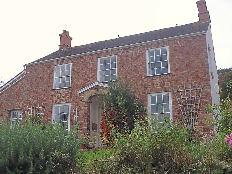
5366 DUNSTER THE BALL
No 3 (Darajini)
SS 9843-9943 4/3
II GV
2.
Mid 19th century. Dressed and coursed random rubble red sandstone. Plain tile roof,
gable end brick stacks. Two storeys. Five windows, sashes with glazing bars, Central
projecting gabled stone porch, moulded coping, carved elliptical arch, spandrels,
plain panelled door, semi-circular fanlight.
Listing NGR: SS9914343904
External links are from the relevant listing authority and, where applicable, Wikidata. Wikidata IDs may be related buildings as well as this specific building. If you want to add or update a link, you will need to do so by editing the Wikidata entry.


Other nearby listed buildings
