Approximate Location Map
Large Map »
Latitude: 51.1828 / 51°10'58"N
Longitude: -3.4446 / 3°26'40"W
OS Eastings: 299129
OS Northings: 143610
OS Grid: SS991436
Mapcode National: GBR LK.5R6G
Mapcode Global: VH6GM.7JVM
Plus Code: 9C3R5HM4+45
Entry Name: Granary, Castle Home Farmyard
Listing Date: 4 August 1983
Grade: II
Source: Historic England
Source ID: 1296332
English Heritage Legacy ID: 264645
ID on this website: 101296332
Location: Dunster, Somerset, TA24
County: Somerset
District: Somerset West and Taunton
Civil Parish: Dunster
Built-Up Area: Dunster
Traditional County: Somerset
Lieutenancy Area (Ceremonial County): Somerset
Tagged with: Granary
1.
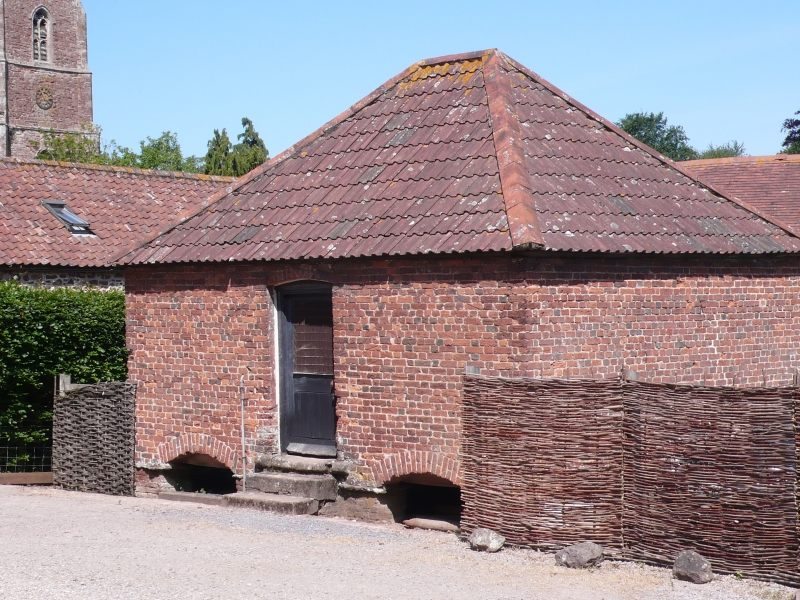
5366 DUNSTER CASTLE HILL
Granary, Castle Home Farmyard
SS 9843-9943 4/14
II GV
2.
Early 19th century. Brick with double Roman tiled, hipped roof. Small square
1½ storey structure. Steps up to granary floor. Two brick segmental arches to basement
openings on each elevation. Plain boarded door. A good example of a local agricultural
building.
Listing NGR: SS9913143609
External links are from the relevant listing authority and, where applicable, Wikidata. Wikidata IDs may be related buildings as well as this specific building. If you want to add or update a link, you will need to do so by editing the Wikidata entry.


Other nearby listed buildings
