Approximate Location Map
Large Map »
Latitude: 51.1916 / 51°11'29"N
Longitude: -3.2256 / 3°13'32"W
OS Eastings: 314452
OS Northings: 144313
OS Grid: ST144443
Mapcode National: GBR LW.56MR
Mapcode Global: VH6GR.19MV
Plus Code: 9C3R5QRF+JQ
Entry Name: Oil Retort House
Listing Date: 16 November 1984
Grade: II
Source: Historic England
Source ID: 1057429
English Heritage Legacy ID: 265166
ID on this website: 101057429
Location: Somerset, TA5
County: Somerset
District: Somerset West and Taunton
Civil Parish: Kilve
Traditional County: Somerset
Lieutenancy Area (Ceremonial County): Somerset
Tagged with: Architectural structure
ST14SW
5/125
KILVE CP
KILVE PILL
Oil Retort House
GII
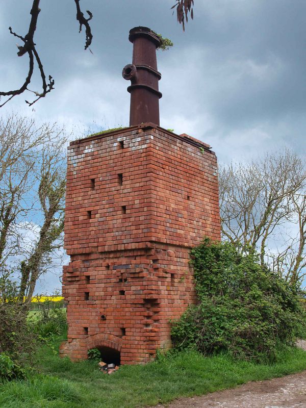
Oil retort house.Circa 1924.Red brick,irregular bond,and cast iron.Roughly square in plan,a rectangular block about four metres high and 2.15x2.45 metres square.Flat roofed,divided by recessed string course with inset cast iron bar on East front,corbelled projection below on all fronts,irregularly placed square ventilation holes,majority on East and West fronts;segmental headed loading opening on West front at ground floor level with cut off pipe above,angled segmental headed opening on North front above low external stepped plinth partially damaged.Surrmounted by cast iron chimney with flange attached on West side,thought to have been an attachment to carry away and condense the vapours,in all about five metres high.In 1916 it was discovered that the shale beds of the North Somerset coast were rich in oil and in 1924 Dr Forbes-Leslie founded the Shaline Company to exploit them.This retort house is thought to be the first structure erected here for the conversion of shale to oil but the company was unable to raise sufficient capital and this is now all that remains of the anticipated Somerset oil boom.Listed primarily for historical interest.(Country Life October 26,1967;photograph in NMR).
Listing NGR: ST1445244313
External links are from the relevant listing authority and, where applicable, Wikidata. Wikidata IDs may be related buildings as well as this specific building. If you want to add or update a link, you will need to do so by editing the Wikidata entry.


Other nearby listed buildings
