Approximate Location Map
Large Map »
Latitude: 51.1477 / 51°8'51"N
Longitude: -2.7154 / 2°42'55"W
OS Eastings: 350057
OS Northings: 138961
OS Grid: ST500389
Mapcode National: GBR MK.7XJL
Mapcode Global: VH8B3.WFC0
Plus Code: 9C3V47XM+3V
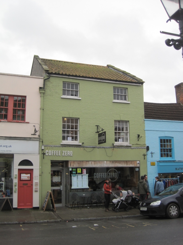
Entry Name: 42, High Street
Listing Date: 15 March 1974
Grade: II
Source: Historic England
Source ID: 1167902
English Heritage Legacy ID: 265948
ID on this website: 101167902
Location: Glastonbury, Somerset, BA6
County: Somerset
District: Mendip
Civil Parish: Glastonbury
Built-Up Area: Glastonbury
Traditional County: Somerset
Lieutenancy Area (Ceremonial County): Somerset
Tagged with: Building
This list entry was subject to a Minor Amendment on 08/11/2012
ST 5038 8/153
1133
HIGH STREET
(South Side)
No 42
GV
II
Early/mid C19, 3 storeys. Painted brick. Pantile roof, eaves conice. 2 windows,
keystones. Sashes with glazing bars. Modern shop-front. Grade II for group value.
Flats 1, 2 and 3 King Arthurs Court and nos. 38 to 42 (even) High Street form a group.
Listing NGR: ST5005738960
External links are from the relevant listing authority and, where applicable, Wikidata. Wikidata IDs may be related buildings as well as this specific building. If you want to add or update a link, you will need to do so by editing the Wikidata entry.


Other nearby listed buildings
