Approximate Location Map
Large Map »
Latitude: 51.1448 / 51°8'41"N
Longitude: -2.7172 / 2°43'1"W
OS Eastings: 349924
OS Northings: 138641
OS Grid: ST499386
Mapcode National: GBR MK.83DX
Mapcode Global: VH8B3.VHC7
Plus Code: 9C3V47VM+W4
Entry Name: Chaingate
Listing Date: 15 March 1974
Grade: II
Source: Historic England
Source ID: 1057906
English Heritage Legacy ID: 265977
ID on this website: 101057906
Location: Glastonbury, Somerset, BA6
County: Somerset
District: Mendip
Civil Parish: Glastonbury
Built-Up Area: Glastonbury
Traditional County: Somerset
Lieutenancy Area (Ceremonial County): Somerset
Tagged with: Building
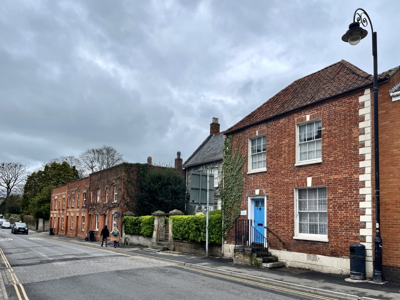
MAGDALENE STREET
1.
1133
(East Side)
No 21
(Chaingate)
ST 4938 7/76
II GV
2.
Probably early C19, much altered. 2 storeys. Red brick with ashlar dressings.
Hipped pantile roof. Banded quoins. 2 windows. Plain keyblocks. Modern metal-framed
windows. 5 steps with railings lead up to doorway. Plain wood architrave. Modern
1/2-glazed door. Grade II for group value.
Nos 19 to 23 (odd) and Nos 1 to 6 (consec) The Armoury all form a group.
Listing NGR: ST4992238642
External links are from the relevant listing authority and, where applicable, Wikidata. Wikidata IDs may be related buildings as well as this specific building. If you want to add or update a link, you will need to do so by editing the Wikidata entry.


Other nearby listed buildings
