Approximate Location Map
Large Map »
Latitude: 51.1447 / 51°8'41"N
Longitude: -2.7175 / 2°43'2"W
OS Eastings: 349905
OS Northings: 138631
OS Grid: ST499386
Mapcode National: GBR MK.83BR
Mapcode Global: VH8B3.VH79
Plus Code: 9C3V47VM+V2
Entry Name: 44-50, Magdalene Street
Listing Date: 15 March 1974
Grade: II
Source: Historic England
Source ID: 1172899
English Heritage Legacy ID: 265988
ID on this website: 101172899
Location: Glastonbury, Somerset, BA6
County: Somerset
District: Mendip
Civil Parish: Glastonbury
Built-Up Area: Glastonbury
Traditional County: Somerset
Lieutenancy Area (Ceremonial County): Somerset
Tagged with: Building
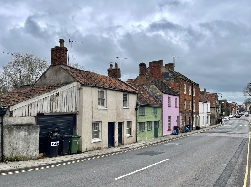
MAGDALENE STREET
1.
1133
(West Side)
Nos 44 to 50 (even)
ST 4938 7/169
II GV
2.
Late C17 and later. Row of 2-storey cottages of differing elevations. All have
painted fronts (No 46 with rubble) and pantile roofs. 6 windows in all. Mostly
sashes with glazing bars. No 46 has 2 and 3-light casements. 4 doorways, No 44
with 2-panel door. Lean-to wooden extension to left of No 50.
Nos 40 to 50 (even) form a group.
Listing NGR: ST4990238642
External links are from the relevant listing authority and, where applicable, Wikidata. Wikidata IDs may be related buildings as well as this specific building. If you want to add or update a link, you will need to do so by editing the Wikidata entry.


Other nearby listed buildings
