Approximate Location Map
Large Map »
Latitude: 51.232 / 51°13'55"N
Longitude: -2.3259 / 2°19'33"W
OS Eastings: 377342
OS Northings: 148146
OS Grid: ST773481
Mapcode National: GBR 0S9.LSR
Mapcode Global: VH97D.M9RC
Plus Code: 9C3V6MJF+RJ
Entry Name: Castle House
Listing Date: 31 January 1974
Last Amended: 16 February 1983
Grade: II
Source: Historic England
Source ID: 1057869
English Heritage Legacy ID: 266082
ID on this website: 101057869
Location: Frome, Somerset, BA11
County: Somerset
District: Mendip
Civil Parish: Frome
Built-Up Area: Frome
Traditional County: Somerset
Lieutenancy Area (Ceremonial County): Somerset
Tagged with: House
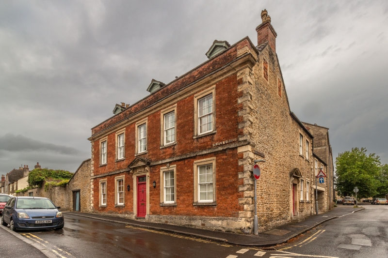
1.
5363 CASTLE STREET
(North-West side)
No 23
ST 7748 SW 4/130 Castle House
GV (formerly listed as
II 31.1.74 House on Corner of
Castle Street and
Trinity Street)
2.
Formerly Castle House. Frome Hospital in late C19. Late C17 remodelled. Front
of red brick with stone dressings probably mid C18. Stone plinth, chamfered
quoins, 1st floor band, moulded cornice, brick parapet (a blocking course with
edgemould and brick parapet over with stone coping. 2 storeys and attic.
Pantile roof with former. 5 windows, cross-glazed sashes in moulded stone
architraves (blocked on ground floor at time of survey 1979). Centre ground floor
window formerly a door has bracketted stone pediment with fluted lintel containing
shaped tablet. Return elevation to Trinity Street is a 2 window rubble extension
with end quoins and outer ogee mouldings to dressings; similar doorway with
bracketted pediment. 2 blocked lights to gable. Said to be the oldest surviving
brick building in Frome. Gables stair turret to rear. Late C18 fittings inside
including modillion and rosette ceiling cornices. Staircase has open string,
turned balusters and moulded mahogany hand rail, landing to attic. Became Cottage
Hospital 1875; disused at time of re-survey (1979). RCHM - Trinity Area).
Listing NGR: ST7734248146
External links are from the relevant listing authority and, where applicable, Wikidata. Wikidata IDs may be related buildings as well as this specific building. If you want to add or update a link, you will need to do so by editing the Wikidata entry.


Other nearby listed buildings
