Approximate Location Map
Large Map »
Latitude: 51.2088 / 51°12'31"N
Longitude: -2.3805 / 2°22'49"W
OS Eastings: 373516
OS Northings: 145584
OS Grid: ST735455
Mapcode National: GBR 0SL.4ZF
Mapcode Global: VH97C.PWD5
Plus Code: 9C3V6J59+GR
Entry Name: Brazenhall
Listing Date: 27 November 1984
Grade: II
Source: Historic England
Source ID: 1174642
English Heritage Legacy ID: 266822
ID on this website: 101174642
Location: Nunney, Somerset, BA11
County: Somerset
District: Mendip
Civil Parish: Nunney
Built-Up Area: Nunney
Traditional County: Somerset
Lieutenancy Area (Ceremonial County): Somerset
Tagged with: Building
ST7345
12/123
NUNNEY CP
HORN STREET (West side)
No 14
(Brazenhall)
GV
II
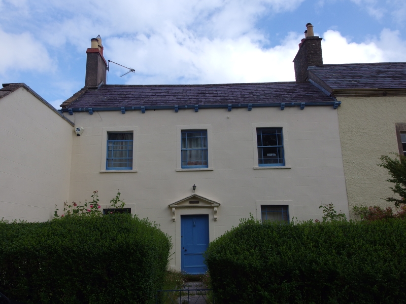
House, part of row. Circa 1750, early C19 alterations. Smooth render, slate roof, rendered stack. 2-storeys, 3-bays,
sash windows with verge lights in slightly raised surrounds Central door opening in similar surround, triangular
pediment on stone brackets, half glazed door. Outshut of one bay to left side, C20 half glazed door.
Listing NGR: ST7351645584
External links are from the relevant listing authority and, where applicable, Wikidata. Wikidata IDs may be related buildings as well as this specific building. If you want to add or update a link, you will need to do so by editing the Wikidata entry.


Other nearby listed buildings
