Approximate Location Map
Large Map »
Latitude: 51.0156 / 51°0'56"N
Longitude: -3.0938 / 3°5'37"W
OS Eastings: 323365
OS Northings: 124590
OS Grid: ST233245
Mapcode National: GBR M1.JB0N
Mapcode Global: FRA 46DF.JHX
Plus Code: 9C3R2W84+6F
Entry Name: 27-29, East Reach
Listing Date: 4 July 1975
Grade: II
Source: Historic England
Source ID: 1232236
English Heritage Legacy ID: 269682
ID on this website: 101232236
Location: Firepool, Somerset, TA1
County: Somerset
District: Somerset West and Taunton
Electoral Ward/Division: Taunton Eastgate
Parish: Non Civil Parish
Built-Up Area: Taunton
Traditional County: Somerset
Lieutenancy Area (Ceremonial County): Somerset
Tagged with: Building
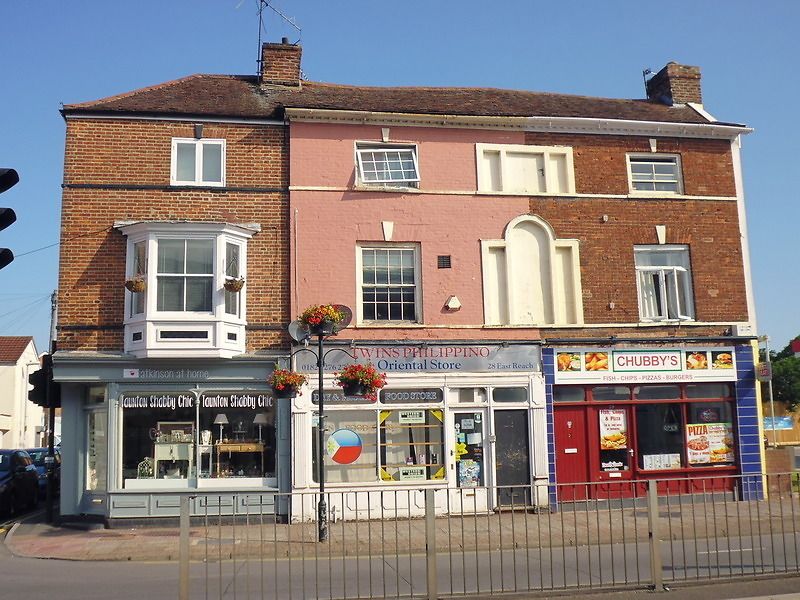
EAST REACH
1.
5365
(North Side)
Nos 27 to 29 (consec)
ST 2324 NW 12/45
II
2.
On the corner with Haydon Road. 3 storey C18 brick front, altered and partly painted.
Tiled roof, dentilled eaves cornice to Nos 28 and 29. Stringcourses, 4 windows
(3 light windows to right blocked). Remaining original sashes have flush frames
and keystones. One 3 light bay to left on lst floor. Modern shop fronts.
Listing NGR: ST2336524590
External links are from the relevant listing authority and, where applicable, Wikidata. Wikidata IDs may be related buildings as well as this specific building. If you want to add or update a link, you will need to do so by editing the Wikidata entry.


Other nearby listed buildings
