Approximate Location Map
Large Map »
Latitude: 51.0341 / 51°2'2"N
Longitude: -3.0127 / 3°0'45"W
OS Eastings: 329088
OS Northings: 126566
OS Grid: ST290265
Mapcode National: GBR M5.H0LC
Mapcode Global: FRA 46LD.04L
Plus Code: 9C3R2XMP+JW
Entry Name: Charlton Bridge
Listing Date: 17 May 1985
Grade: II
Source: Historic England
Source ID: 1308009
English Heritage Legacy ID: 270584
ID on this website: 101308009
Location: Charlton, Somerset, TA3
County: Somerset
District: Somerset West and Taunton
Civil Parish: Creech St. Michael
Traditional County: Somerset
Lieutenancy Area (Ceremonial County): Somerset
Tagged with: Bridge
ST22NE CREECH ST MICHAEL CP
CHARLTON
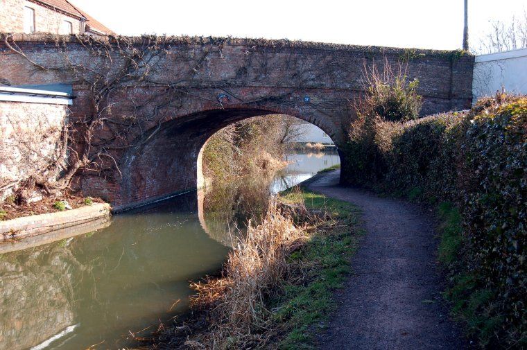
6/74 Charlton Bridge
II
Bridge over Bridgewater and Taunton Canal. 1827, Engineer James Hollingsworth. Red brick, Flemish bond, saddle back
coping. Single span. Retaining wall to towpath on South side, The canal closed 1911. Probably the best surviving
example of a good group of bridges along the canal.
Listing NGR: ST2908826566
External links are from the relevant listing authority and, where applicable, Wikidata. Wikidata IDs may be related buildings as well as this specific building. If you want to add or update a link, you will need to do so by editing the Wikidata entry.


Other nearby listed buildings
