Approximate Location Map
Large Map »
Latitude: 51.0705 / 51°4'13"N
Longitude: -2.9162 / 2°54'58"W
OS Eastings: 335904
OS Northings: 130527
OS Grid: ST359305
Mapcode National: GBR M9.DT5K
Mapcode Global: FRA 46S9.1QY
Plus Code: 9C3V33CM+5G
Entry Name: Remains of Church on Burrow Mump
Listing Date: 29 March 1963
Last Amended: 18 December 1986
Grade: II
Source: Historic England
Source ID: 1344609
English Heritage Legacy ID: 271178
ID on this website: 101344609
Location: Burrowbridge, Somerset, TA7
County: Somerset
District: Somerset West and Taunton
Civil Parish: Burrowbridge
Traditional County: Somerset
Lieutenancy Area (Ceremonial County): Somerset
Tagged with: Church ruin
ST33SE BURROWBRIDGE CP
BURROWBRIDGE VILLAGE
2/13 Remains of church on Burrow Mump
(formerly listed as Church on
Burrow Mump in Othery CP)
29.3.63
II
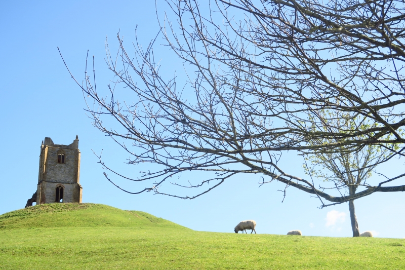
Remains of church. 1793 on site of late medieval church. Squared and coursed lias with red brick and Ham stone
dressings. West tower, 3-bay nave, south porch. Three stage west tower with solid parapet ramped up to obelisk finials,
north-west corner renewed mid C20, diagonal buttress, 2 window openings on west front; slate plaque on south face
inscribed "Burrow Mump. This hill was given to the nation by Alexander Gould Barrett that the men and women of Somerset
who died serving their country in the Second World War may be remembered here and in time to come. Sumorsaete ealle'.
Roofless nave with remains of porch, window openings without tracery including large east end window opening. The
coarse detailing gives the impression that this was errected as an eye-catched rather than as a church. Attempts wade
to erect a chapel of ease in late C18 were abandoned, and in the early C19 the Church of St Michael (qv) was erected at
the foot of the hill. This was not the site of King Alfred's headquarters in 879 as stated in the previous list. It is
a dramatic feature in the flat landscape of the Levels. Scheduled Ancient monument (Somerset County No 203).
(Photograph in NMR; VCH Somerset, Vol 6, forthcoming).
Listing NGR: ST3590430527
This List entry has been amended to add sources for War Memorials Online and the War Memorials Register. These sources were not used in the compilation of this List entry but are added here as a guide for further reading, 15 December 2016.
External links are from the relevant listing authority and, where applicable, Wikidata. Wikidata IDs may be related buildings as well as this specific building. If you want to add or update a link, you will need to do so by editing the Wikidata entry.


Other nearby listed buildings
