Approximate Location Map
Large Map »
Latitude: 52.6996 / 52°41'58"N
Longitude: -1.9964 / 1°59'47"W
OS Eastings: 400337
OS Northings: 311327
OS Grid: SK003113
Mapcode National: GBR 29L.L32
Mapcode Global: WHBFG.9DKR
Plus Code: 9C4WM2X3+RC
Entry Name: Cross Keys Farmhouse
Listing Date: 21 December 1973
Grade: II
Source: Historic England
Source ID: 1344627
English Heritage Legacy ID: 271288
ID on this website: 101344627
Location: Hill Top, Cannock Chase, Staffordshire, WS12
County: Staffordshire
District: Cannock Chase
Civil Parish: Hednesford
Built-Up Area: Cannock
Traditional County: Staffordshire
Lieutenancy Area (Ceremonial County): Staffordshire
Church of England Parish: Hednesford St Peter
Church of England Diocese: Lichfield
Tagged with: Farmhouse
SK 01 SW
3/12
Hednesford
HILL STREET
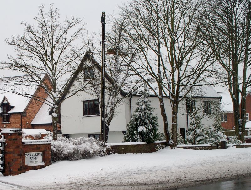
Cross Keys Farmhouse
II
Probably C16. Plaster to earlier timber frame; two storeys plus attic; over-sailing first floor and gable end; five modern casement windows; sprocket eaves; tiles. Later additions at rear. The interior has C17 heraldic plaster frieze to the main bedroom.
Listing NGR: SK0033711327
External links are from the relevant listing authority and, where applicable, Wikidata. Wikidata IDs may be related buildings as well as this specific building. If you want to add or update a link, you will need to do so by editing the Wikidata entry.


Other nearby listed buildings
