Approximate Location Map
Large Map »
Latitude: 52.6808 / 52°40'50"N
Longitude: -2.1568 / 2°9'24"W
OS Eastings: 389497
OS Northings: 309241
OS Grid: SJ894092
Mapcode National: GBR 187.TTB
Mapcode Global: WHBFC.VW47
Plus Code: 9C4VMRJV+87
Entry Name: Somerford Bridge
Listing Date: 28 March 1985
Grade: II
Source: Historic England
Source ID: 1295192
English Heritage Legacy ID: 271343
ID on this website: 101295192
Location: Somerford, South Staffordshire, ST19
County: Staffordshire
District: South Staffordshire
Civil Parish: Brewood and Coven
Traditional County: Staffordshire
Lieutenancy Area (Ceremonial County): Staffordshire
Church of England Parish: Brewood St Mary and St Chad
Church of England Diocese: Lichfield
Tagged with: Bridge
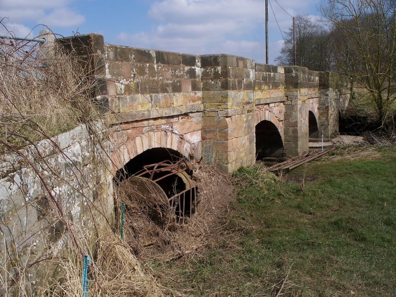
BREWOOD C.P. CLAYGATES ROAD
SJ 80 NE
4/37 Somerford Bridge
- II
Bridge. Probably C17 in origin but rebuilt in 1796.
Ashlar. 4 segmental arches spanning the river Penk
between Brewood and Four Ashes; angled buttresses with
refuges at parapet level. V.C.H. Staffordshire, VoL V.
1959.
Listing NGR: SJ8949709241
External links are from the relevant listing authority and, where applicable, Wikidata. Wikidata IDs may be related buildings as well as this specific building. If you want to add or update a link, you will need to do so by editing the Wikidata entry.


Other nearby listed buildings
