Approximate Location Map
Large Map »
Latitude: 52.5909 / 52°35'27"N
Longitude: -2.2594 / 2°15'34"W
OS Eastings: 382520
OS Northings: 299262
OS Grid: SO825992
Mapcode National: GBR 07X.KLG
Mapcode Global: WHBFX.84BL
Plus Code: 9C4VHPRR+96
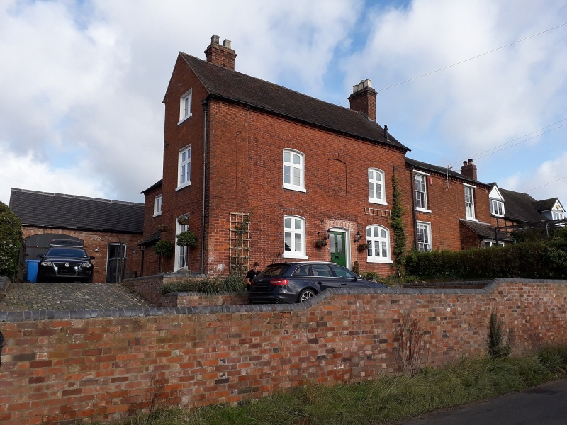
Entry Name: Highgate House
Listing Date: 28 March 1985
Grade: II
Source: Historic England
Source ID: 1188668
English Heritage Legacy ID: 271494
ID on this website: 101188668
Location: Pattingham, South Staffordshire, WV6
County: Staffordshire
District: South Staffordshire
Civil Parish: Pattingham and Patshull
Built-Up Area: Pattingham
Traditional County: Staffordshire
Lieutenancy Area (Ceremonial County): Staffordshire
Church of England Parish: Pattingham St Chad
Church of England Diocese: Lichfield
Tagged with: House
PATTINGHAM C.P. WOLVERHAMPTON ROAD
SO 89 NW (North side)
11/180 No. 13 (Highgate House)
G.V. II
House. Early C19. Red brick; clay tile roof; brick end
stacks. 2 storeys; 3 windows; casements with segmental
heads, blind first floor centre window; C20 central porch
with glazed door. Included for group value.
Listing NGR: SO8252099262
External links are from the relevant listing authority and, where applicable, Wikidata. Wikidata IDs may be related buildings as well as this specific building. If you want to add or update a link, you will need to do so by editing the Wikidata entry.


Other nearby listed buildings
