Approximate Location Map
Large Map »
Latitude: 52.7457 / 52°44'44"N
Longitude: -1.8875 / 1°53'14"W
OS Eastings: 407693
OS Northings: 316453
OS Grid: SK076164
Mapcode National: GBR 3BG.X6W
Mapcode Global: WHBF9.Z7CY
Plus Code: 9C4WP4W7+72
Entry Name: Church Farmhouse
Listing Date: 28 January 1988
Grade: II
Source: Historic England
Source ID: 1374296
English Heritage Legacy ID: 272852
ID on this website: 101374296
Location: Mavesyn Ridware, Lichfield, Staffordshire, WS15
County: Staffordshire
District: Lichfield
Civil Parish: Armitage with Handsacre
Built-Up Area: Armitage
Traditional County: Staffordshire
Lieutenancy Area (Ceremonial County): Staffordshire
Church of England Parish: Armitage St John Baptist
Church of England Diocese: Lichfield
Tagged with: Farmhouse
SK 01 NE
6/6
ARMITAGE WITH HANDSACRE C.P.
CHURCH LANE
Church Farmhouse
GV
II
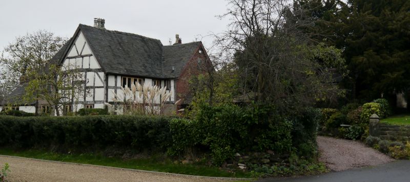
Farmhouse, now house. C17 with C18 and C20 additions. Timber framed with brick and stone additions, plain tile roofs; brick lateral stacks.
T-shaped plan; main range aligned north-south facing east with crosswing to the north. Rear extension wing to the west. Two storey main range to the left with sandstone plinth and timber framing of three square panels to eaves level. Gabled crosswing of two storeys and attic to the right fronted in brick in the early C18. Exposed framing of closely spaced studs to first floor of left hand return on a high sandstone plinth. Irregular C20 fenestration. C20 gabled porch to left hand side of crosswing. Exposed collar and tie beam roof truss to left hand gable of main range with V-struts above the collar and four vertical struts below.
Interior. Chamfered and stopped ceiling beams. C19/C20 staircase in a late C17 style: with splat balusters.
Listing NGR: SK0769316453
External links are from the relevant listing authority and, where applicable, Wikidata. Wikidata IDs may be related buildings as well as this specific building. If you want to add or update a link, you will need to do so by editing the Wikidata entry.


Other nearby listed buildings
