Approximate Location Map
Large Map »
Latitude: 52.8774 / 52°52'38"N
Longitude: -1.936 / 1°56'9"W
OS Eastings: 404402
OS Northings: 331105
OS Grid: SK044311
Mapcode National: GBR 38V.P9Z
Mapcode Global: WHBDJ.7YB0
Plus Code: 9C4WV3G7+XH
Entry Name: Bridge Approximately 30 Metres South of Burndhurst Mill
Listing Date: 8 August 1985
Grade: II
Source: Historic England
Source ID: 1374508
English Heritage Legacy ID: 273890
ID on this website: 101374508
Location: Leese Hill, East Staffordshire, ST14
County: Staffordshire
District: East Staffordshire
Civil Parish: Uttoxeter Rural
Traditional County: Staffordshire
Lieutenancy Area (Ceremonial County): Staffordshire
Church of England Parish: Gratwich St Mary the Virgin
Church of England Diocese: Lichfield
Tagged with: Bridge
SK 03 SW
5/117
A518
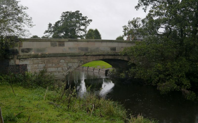
Bridge approximately 30 metres south of Burndhurst Mill.
GV
II
Road bridge. Early C19. Ashlar. Single segmental arch spanning
the River Blithe; parapet band to plain parapet terminated by
octagonal piers.
Listing NGR: SK0440231105
External links are from the relevant listing authority and, where applicable, Wikidata. Wikidata IDs may be related buildings as well as this specific building. If you want to add or update a link, you will need to do so by editing the Wikidata entry.


Other nearby listed buildings
