Approximate Location Map
Large Map »
Latitude: 52.9856 / 52°59'8"N
Longitude: -1.9888 / 1°59'19"W
OS Eastings: 400850
OS Northings: 343143
OS Grid: SK008431
Mapcode National: GBR 263.VBK
Mapcode Global: WHBD3.F66Z
Plus Code: 9C4WX2P6+7F
Entry Name: St Giles Roman Catholic Primary School
Listing Date: 8 August 1986
Grade: II
Source: Historic England
Source ID: 1281192
English Heritage Legacy ID: 274828
ID on this website: 101281192
Location: Cheadle, Staffordshire Moorlands, Staffordshire, ST10
County: Staffordshire
District: Staffordshire Moorlands
Civil Parish: Cheadle
Built-Up Area: Cheadle
Traditional County: Staffordshire
Lieutenancy Area (Ceremonial County): Staffordshire
Church of England Parish: Cheadle St Giles
Church of England Diocese: Lichfield
Tagged with: School building
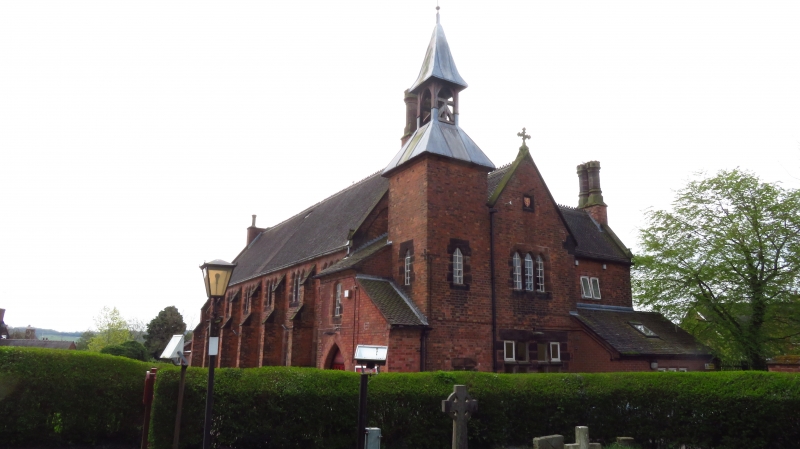
SK 0043-0143 CHEADLE C.P. BANK STREET (south side)
11/26 St. Giles R. C. Primary
School
GV II
School. 1841-6 by Augustus Welby Northmore Pugin. Red brick with stone dressings; tiled roof with crested ridge and verge parapets. Castellated triple-
shafted stack to right-hand apex. Two-storey, six-bay front divided
by stone-capped two-stage buttresses with three-light stone dressed
windows to upper floor over four-light to ground floor, all with trefoil
heads; slightly set away from the right hand end: a bell tower with
pyramidal two-stage lead roof with timber framing to the bellcote and
trefoil-headed window to first floor. The entrance bay projects under
a low catslide roof between school and tower. Pent roof running flush
to right clasps front of tower. The north front is highly assymetrical
and in contrast to the body of the building. A Tudor-arch first-floor
window is set over pointed-arch entrance with doors set well back into
reveal. W. G. Short: Pugin's Gem: A History of St. Giles Catholic
Church, Cheadle, Staffordshire 1981, p.19.
Listing NGR: SK0085043143
External links are from the relevant listing authority and, where applicable, Wikidata. Wikidata IDs may be related buildings as well as this specific building. If you want to add or update a link, you will need to do so by editing the Wikidata entry.


Other nearby listed buildings
