Approximate Location Map
Large Map »
Latitude: 52.9868 / 52°59'12"N
Longitude: -1.9899 / 1°59'23"W
OS Eastings: 400771
OS Northings: 343278
OS Grid: SK007432
Mapcode National: GBR 263.MQV
Mapcode Global: WHBD3.D6M1
Plus Code: 9C4WX2P6+P2
Entry Name: 62, High Street
Listing Date: 8 August 1986
Grade: II
Source: Historic England
Source ID: 1281112
English Heritage Legacy ID: 274852
ID on this website: 101281112
Location: Cheadle, Staffordshire Moorlands, Staffordshire, ST10
County: Staffordshire
District: Staffordshire Moorlands
Civil Parish: Cheadle
Built-Up Area: Cheadle
Traditional County: Staffordshire
Lieutenancy Area (Ceremonial County): Staffordshire
Church of England Parish: Cheadle St Giles
Church of England Diocese: Lichfield
Tagged with: Building
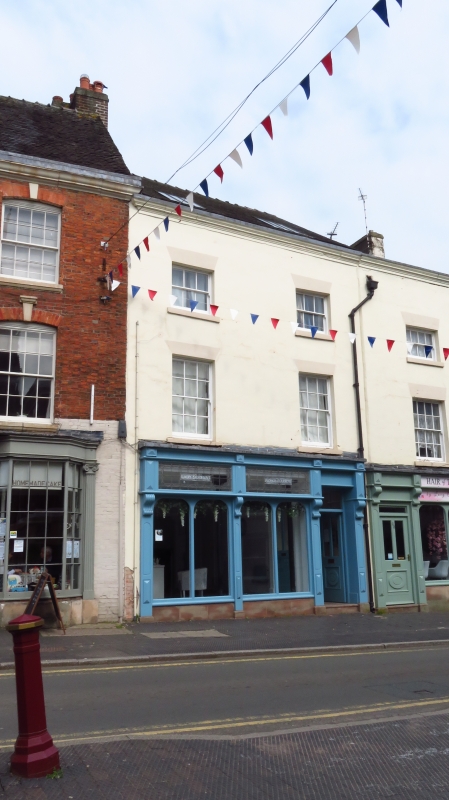
SK 0043-0143 CHEADLE C.P. HIGH STREET (North side)
11/50 No. 62
GV II
Shop. Early C19 with C20 shopfront. Rendered brickwork; tiled roof
on moulded eaves. Three-storey 2-window front; glazing bar sashes.
Included for group value in prominent town centre location and adjacent
to No. 64 (qv).
Listing NGR: SK0076843281
External links are from the relevant listing authority and, where applicable, Wikidata. Wikidata IDs may be related buildings as well as this specific building. If you want to add or update a link, you will need to do so by editing the Wikidata entry.


Other nearby listed buildings
