Approximate Location Map
Large Map »
Latitude: 52.9862 / 52°59'10"N
Longitude: -1.9925 / 1°59'33"W
OS Eastings: 400599
OS Northings: 343209
OS Grid: SK005432
Mapcode National: GBR 263.T7S
Mapcode Global: WHBD3.C6FJ
Plus Code: 9C4WX2P4+FX
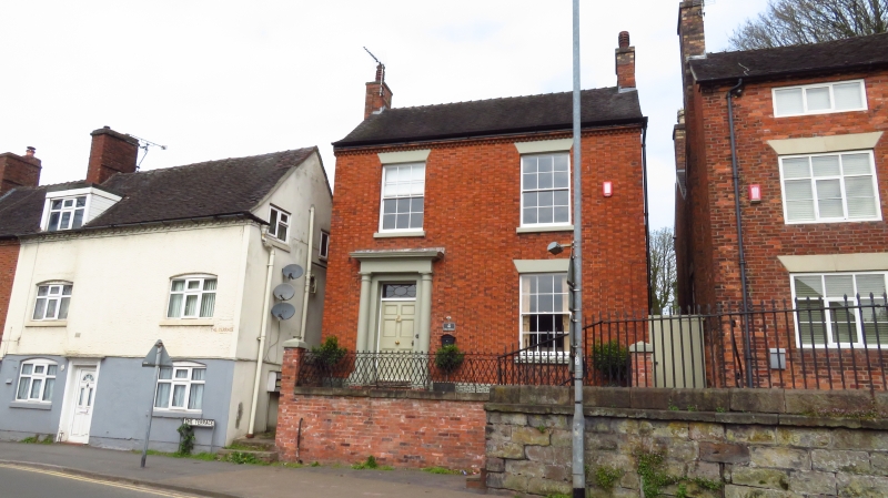
Entry Name: 4, the Terrace
Listing Date: 8 August 1986
Grade: II
Source: Historic England
Source ID: 1281015
English Heritage Legacy ID: 274894
ID on this website: 101281015
Location: Cheadle, Staffordshire Moorlands, Staffordshire, ST10
County: Staffordshire
District: Staffordshire Moorlands
Civil Parish: Cheadle
Built-Up Area: Cheadle
Traditional County: Staffordshire
Lieutenancy Area (Ceremonial County): Staffordshire
Church of England Parish: Cheadle St Giles
Church of England Diocese: Lichfield
Tagged with: Building
SK 0043-0143 CHEADLE C.P. THE TERRACE
11/91 No. 4
GV II
House. Early to mid C19. Diapered red brick; tiled roof on cogged
eaves; end stacks. Two-storey, two-window front; glazing bar sashes
with painted wedged heads; painted Tuscan doorcase to left with overlight
and 6-panel door.
Listing NGR: SK0059943209
External links are from the relevant listing authority and, where applicable, Wikidata. Wikidata IDs may be related buildings as well as this specific building. If you want to add or update a link, you will need to do so by editing the Wikidata entry.


Other nearby listed buildings
