Approximate Location Map
Large Map »
Latitude: 52.9796 / 52°58'46"N
Longitude: -1.8925 / 1°53'32"W
OS Eastings: 407316
OS Northings: 342478
OS Grid: SK073424
Mapcode National: GBR 37R.8BZ
Mapcode Global: WHBD4.XC0M
Plus Code: 9C4WX4H5+R2
Entry Name: St Johns Preparatory School
Listing Date: 3 January 1967
Last Amended: 17 November 1986
Grade: II*
Source: Historic England
Source ID: 1037917
English Heritage Legacy ID: 275005
ID on this website: 101037917
Location: Alton, Staffordshire Moorlands, Staffordshire, ST10
County: Staffordshire
District: Staffordshire Moorlands
Civil Parish: Alton
Built-Up Area: Alton
Traditional County: Staffordshire
Lieutenancy Area (Ceremonial County): Staffordshire
Church of England Parish: Alton St Peter
Church of England Diocese: Lichfield
Tagged with: School building
ALTON C.P. CASTLE HILL ROAD (North side)
SK 0642-0742
13/9 St. John's Preparatory
3/1/67 School (Formerly listed as
"The Convent")
GV II*
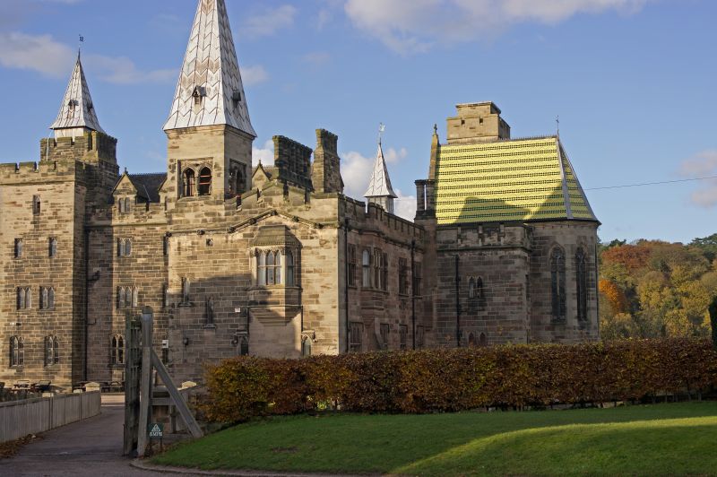
House now school. 1847. By Augustus Welby Northmore Pugin for the
16th Earl of Shrewsbury. Ashlar with edged herringbone tooling; plain tile roofs with crested ridge tiles; ashlar ridge stacks and integral end stacks
with octagonal shafts and crenellated caps. Castellated style with
Gothic details; L-shaped plan house, chapel attached to the east end
to make a T-shaped plan; principal alignment east-west, 2 courtyards
to the south. North front: 3-storey, 5-bay main house to the right
and 2-storey, 3-bay wing to the left, 4 storey projecting corner towers
to left and right, the latter has a pyramidal spire; mainly 2-light
mullioned windows to the house, the towers have mainly single-light
rectangular loops, the main house has 2-storey bay window to the right
and to left of centre; crenellated parapets throughout; chapel set-
back to the left of the house. South front: main house to left of
3 storeys and attic on basement with projecting 4-storey left hand
corner tower and 2-storey right hand porch, projecting wing attached
to the right, single set-back bay to the far right linking the house
to the chapel which it partly obscured. Main house: 2:4 bays,
transomed windows, those to ground floor have cambered arches, those
to first and second floor have flat arches, all have trefoil-headed
lights, gabled attic dormers to principal range with paired
Caernarvon arch lights; the porch has a pointed door and block stopped
hood mould, shield above bearing a rampant lion, first floor window of
2 cinquefoil headed and transomed lights under a square head;
crenellated parapets throughout. Right hand wing: 2 storeys on
basement; about 6 bays, the east and west sides have square headed
transomed windows with cinquefoil headed lights, except those to
ground floor west which are 4-centred arch windows of 2 cinquefoil
headed lights; the south gable has a corbelled out oriel window to
the right with brattished band to a hipped roof, and single-light stair
windows to the left, the south-west corner is capped by a turret (Pugin's
"look out tower") with pyramidal roof and openings of two 4-centred
lights with panelled spandrels. Chapel: taller 2-bay chancel with
semi-octagonal east end and moulded eaves cornice to a brightly coloured
fishscale tile roof, hipped towards the east; tall slim pointed windows
of 2-lights with encircled quatrefoil in the head. Interior: rib-
vaulted roof, the ribs springing from wall shafts supported on corbels
carved as angels. St. John's Preparatory School is part of an important
complex of buildings designed by Pugin for the 16th Earl of Shrewsbury;
its site on the edge of a cliff overlooking the Churnet Valley, and its
architectural style are reminiscent of the castles of the Rhine which
may have provided a source of inspiration. B.O.E. p. 59; C.L.
November 24, 1960, pp. 1226-1229.
Listing NGR: SK0731642478
External links are from the relevant listing authority and, where applicable, Wikidata. Wikidata IDs may be related buildings as well as this specific building. If you want to add or update a link, you will need to do so by editing the Wikidata entry.


Other nearby listed buildings
