Approximate Location Map
Large Map »
Latitude: 53.0607 / 53°3'38"N
Longitude: -1.8805 / 1°52'49"W
OS Eastings: 408102
OS Northings: 351502
OS Grid: SK081515
Mapcode National: GBR 36S.5CM
Mapcode Global: WHCDX.2BSF
Plus Code: 9C5W3469+7Q
Entry Name: Village Pump and Trough
Listing Date: 17 November 1986
Grade: II
Source: Historic England
Source ID: 1286537
English Heritage Legacy ID: 275189
ID on this website: 101286537
Location: Waterfall, Staffordshire Moorlands, Staffordshire, ST10
County: Staffordshire
District: Staffordshire Moorlands
Civil Parish: Waterhouses
Traditional County: Staffordshire
Lieutenancy Area (Ceremonial County): Staffordshire
Church of England Parish: Waterfall St James and St Bartholomew
Church of England Diocese: Lichfield
Tagged with: Well
SK 05 SE
1/191
WATERHOUSES C.P.
WATERFALL
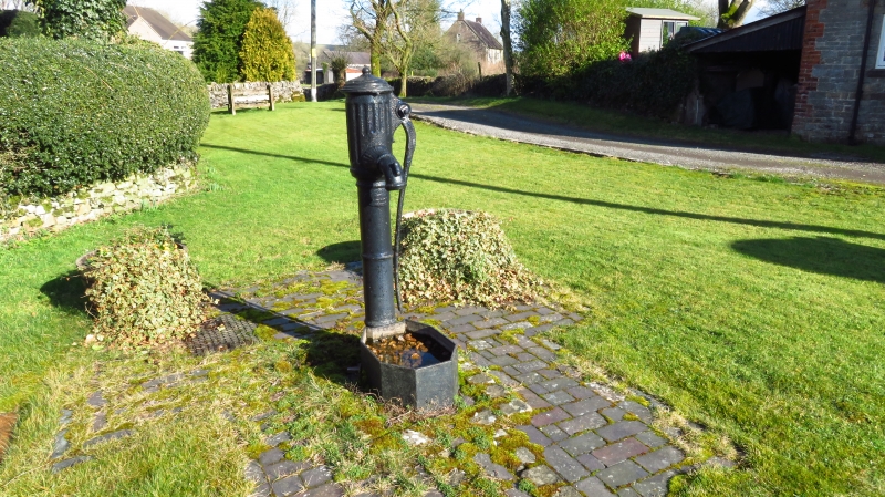
Village pump and trough
GV
II
Pump and trough. Late C19. Cast iron. Cylindrical stem with
enlarged fluted head, curved handle and spout. Elongated octagonal
trough.
Listing NGR: SK0810251502
External links are from the relevant listing authority and, where applicable, Wikidata. Wikidata IDs may be related buildings as well as this specific building. If you want to add or update a link, you will need to do so by editing the Wikidata entry.


Other nearby listed buildings
