Approximate Location Map
Large Map »
Latitude: 53.1784 / 53°10'42"N
Longitude: -2.0423 / 2°2'32"W
OS Eastings: 397272
OS Northings: 364592
OS Grid: SJ972645
Mapcode National: GBR 23Q.LJ7
Mapcode Global: WHBC3.LCQP
Plus Code: 9C5V5XH5+93
Entry Name: Swythamley Hall
Listing Date: 22 October 1952
Last Amended: 20 November 1987
Grade: II
Source: Historic England
Source ID: 1037821
English Heritage Legacy ID: 275271
ID on this website: 101037821
Location: Staffordshire Moorlands, Staffordshire, SK11
County: Staffordshire
District: Staffordshire Moorlands
Civil Parish: Heaton
Traditional County: Staffordshire
Lieutenancy Area (Ceremonial County): Staffordshire
Church of England Parish: Rushton Spencer St Lawrence
Church of England Diocese: Lichfield
Tagged with: House
HEATON C.P. SWYTHAMLEY PARK
SJ 96 SE
5/62 Swythamley Hall
-
GV II
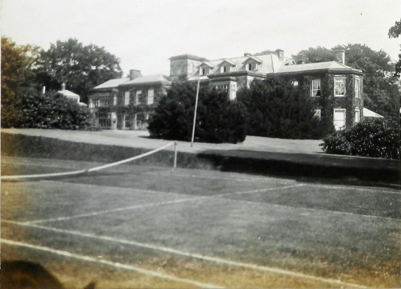
Country house. Medieval hunting lodge foundation, early C19 core,
considerably enlarged circa 1897 by Phillip Brocklehurst. Coursed stone,
rock-faced quoins to late C19 work; slate roof hipped to late C19 parts.
Irregular plan and frontage with classical, Italianate and Jacobean
elements. Entrance front: of 4 main parts, and with continuous eaves,
cornice and blocking course which serves to unify structure; side
stacks. 2 storeys except to early C19 centre core with 3 gabled dormers
to gabled attic; 2 original gables to left half over C20 mullioned and
transomed bay windows and projecting flat-roofed porch to right half with
central flat-roofed 2-storey bay; 5-light mullion and transom window
to first floor and round-arch entry to ground flanked by tall cruciform
windows. South wing: to right of 3 windows (glazing bar sashes as are
all other remaining windows) with break to end bay and string at first
floor level, run round into 3-sided bay facing south. North pavilion:
of 3 windows and string at first floor level set forward from frontage
and linked to house by Italianate tower of 3 stages defined by strings
with 2 blind round-arched openings to top stage and door to base. A
fire of 1813 destroyed all of the original house except the 'new wing'
of which the left half is still visible in the entrance front. Interior:
early C19 top-lit stairs with enriched cornice to well.
Listing NGR: SJ9727264592
External links are from the relevant listing authority and, where applicable, Wikidata. Wikidata IDs may be related buildings as well as this specific building. If you want to add or update a link, you will need to do so by editing the Wikidata entry.


Other nearby listed buildings
