Approximate Location Map
Large Map »
Latitude: 52.0536 / 52°3'13"N
Longitude: 1.1625 / 1°9'45"E
OS Eastings: 616926
OS Northings: 244192
OS Grid: TM169441
Mapcode National: GBR VP7.6R4
Mapcode Global: VHLBT.3NF1
Plus Code: 9F433537+F2
Entry Name: Cast Iron Bollards
Listing Date: 4 August 1972
Grade: II
Source: Historic England
Source ID: 1279645
English Heritage Legacy ID: 275553
ID on this website: 101279645
Location: Ipswich, Suffolk, IP4
County: Suffolk
District: Ipswich
Electoral Ward/Division: Alexandra
Parish: Non Civil Parish
Built-Up Area: Ipswich
Traditional County: Suffolk
Lieutenancy Area (Ceremonial County): Suffolk
Church of England Parish: Ipswich St Clement with St Luke
Church of England Diocese: St.Edmundsbury and Ipswich
Tagged with: Bollard
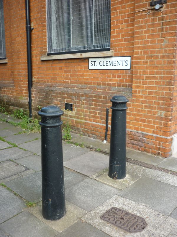
1.
1260 ST CLEMENT'S CHURCH LANE
Cast Iron Bollards
TM 1644 SE 4/318
II
2.
A group of 6 C19 cast iron bollards with ringed and domed caps. 2 at the
entrance on Grimwade Street, one at the entrance on Fore Street and 3 along
the length of St Clement's Church Lane.
Listing NGR: TM1692644192
External links are from the relevant listing authority and, where applicable, Wikidata. Wikidata IDs may be related buildings as well as this specific building. If you want to add or update a link, you will need to do so by editing the Wikidata entry.


Other nearby listed buildings
