Approximate Location Map
Large Map »
Latitude: 52.146 / 52°8'45"N
Longitude: 0.8669 / 0°52'0"E
OS Eastings: 596252
OS Northings: 253625
OS Grid: TL962536
Mapcode National: GBR RHP.HYT
Mapcode Global: VHKDS.ZB46
Plus Code: 9F424VW8+CP
Entry Name: 23 and 24, the Street
Listing Date: 10 July 1980
Grade: II
Source: Historic England
Source ID: 1037357
English Heritage Legacy ID: 276354
ID on this website: 101037357
Location: Brettenham, Babergh, Suffolk, IP7
County: Suffolk
District: Babergh
Civil Parish: Brettenham
Traditional County: Suffolk
Lieutenancy Area (Ceremonial County): Suffolk
Church of England Parish: Brettenham
Church of England Diocese: St.Edmundsbury and Ipswich
Tagged with: Building
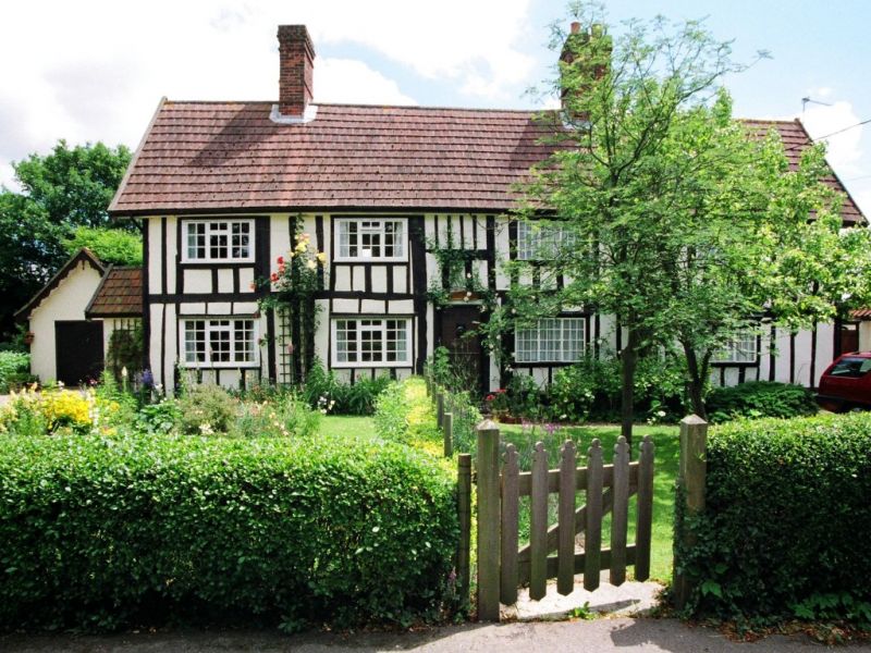
BRETTENHAM THE STREET
1.
5377
Nos 23 and 24
TL 95 SE 33/207
II
2.
A C16-C17 timber-framed and plastered building. Restored and renovated,
with all the timber-framing exposed on the front. Roof tiled (modern),
with 2 ridge chimney stacks (one square). Two storeys. Four window
range of modern casements.
Listing NGR: TL9625253625
External links are from the relevant listing authority and, where applicable, Wikidata. Wikidata IDs may be related buildings as well as this specific building. If you want to add or update a link, you will need to do so by editing the Wikidata entry.


Other nearby listed buildings
