Approximate Location Map
Large Map »
Latitude: 52.1072 / 52°6'25"N
Longitude: 0.7955 / 0°47'43"E
OS Eastings: 591537
OS Northings: 249111
OS Grid: TL915491
Mapcode National: GBR RHZ.XLK
Mapcode Global: VHKDY.Q9XH
Plus Code: 9F424Q4W+V6
Entry Name: 4, Church Street
Listing Date: 21 March 1962
Grade: II
Source: Historic England
Source ID: 1285410
English Heritage Legacy ID: 276661
ID on this website: 101285410
Location: Lavenham, Babergh, Suffolk, CO10
County: Suffolk
District: Babergh
Civil Parish: Lavenham
Built-Up Area: Lavenham
Traditional County: Suffolk
Lieutenancy Area (Ceremonial County): Suffolk
Church of England Parish: Lavenham St Peter and St Paul
Church of England Diocese: St.Edmundsbury and Ipswich
Tagged with: Building
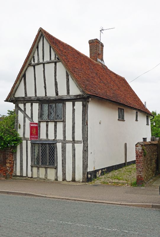
LAVENHAM CHURCH STREET
1.
5377
(south-east side)
No 4
TL 9149 50/514 21.3.62
II GV
2.
A C16 timber-framed and plastered building with a gabled front to the
street. Roof tiled. The timber-framing is exposed on the west front.
Two storeys. One window range of 3-light casements with lattice leaded
lights (restored). Ridge chimney stack.
Listing NGR: TL9153949112
External links are from the relevant listing authority and, where applicable, Wikidata. Wikidata IDs may be related buildings as well as this specific building. If you want to add or update a link, you will need to do so by editing the Wikidata entry.


Other nearby listed buildings
