Approximate Location Map
Large Map »
Latitude: 51.9913 / 51°59'28"N
Longitude: 0.9979 / 0°59'52"E
OS Eastings: 605927
OS Northings: 236787
OS Grid: TM059367
Mapcode National: GBR SM4.13Y
Mapcode Global: VHKFN.76XS
Plus Code: 9F32XXRX+G5
Entry Name: Church of St Mary
Listing Date: 22 February 1955
Grade: II*
Source: Historic England
Source ID: 1351596
English Heritage Legacy ID: 277201
ID on this website: 101351596
Location: St Mary's Church, Holton St Mary, Babergh, Suffolk, CO7
County: Suffolk
District: Babergh
Civil Parish: Holton St. Mary
Traditional County: Suffolk
Lieutenancy Area (Ceremonial County): Suffolk
Church of England Parish: Holton St Mary St Mary
Church of England Diocese: St.Edmundsbury and Ipswich
Tagged with: Church building
TM 03 NE HOLTON ST MARY B1070
(south west side)
2/3
Church of St Mary
22.2.55
GV II*
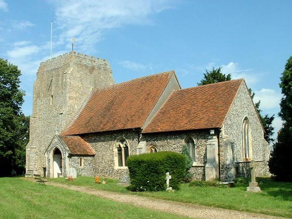
Church. C13-C15, restored 1882. Flint with ashlar dressings. Plain tile roofs.
Apparently truncated west tower, aisleless 2-bay nave and chancel. West tower
2 stages on flushwork plinth, diagonal offset buttresses, later brick embattled
parapet and small amount of patching at summit. 2-light Perpendicular west window.
C19 south porch contains two pews with poppyhead bench ends. Moulded south door
under hoodmould with worn head stops surmounted by pointed niche. 2-light curvi-
linear windows to nave. C14 moulded north door with worn head stops. Chancel at
lower level. Restored Y-tracery windows, moulded priests door. Two offset
buttresses. Renewed east window with intersecting tracery, east wall possibly
rebuilt. Vestry to north. Interior: rendered walls. C19 barrel roof. C15 tower
arch on half-octagonal responds with moulded capitals. C15 octagonal panelled
font on earlier base. C13 piscina with cusped arch on nook shafts with moulded
capitals.
Listing NGR: TM0592736787
External links are from the relevant listing authority and, where applicable, Wikidata. Wikidata IDs may be related buildings as well as this specific building. If you want to add or update a link, you will need to do so by editing the Wikidata entry.


Other nearby listed buildings
