Approximate Location Map
Large Map »
Latitude: 51.9723 / 51°58'20"N
Longitude: 0.7745 / 0°46'28"E
OS Eastings: 590673
OS Northings: 234062
OS Grid: TL906340
Mapcode National: GBR RKP.BM9
Mapcode Global: VHKFJ.CPTD
Plus Code: 9F32XQCF+WR
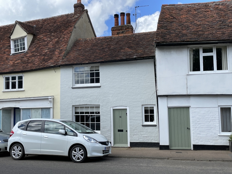
Entry Name: 10, Bridge Street
Listing Date: 9 February 1978
Grade: II
Source: Historic England
Source ID: 1036712
English Heritage Legacy ID: 277877
ID on this website: 101036712
Location: Bures, Babergh, Suffolk, CO8
County: Suffolk
District: Babergh
Civil Parish: Bures St. Mary
Built-Up Area: Bures
Traditional County: Suffolk
Lieutenancy Area (Ceremonial County): Suffolk
Church of England Parish: Bures St Mary
Church of England Diocese: St.Edmundsbury and Ipswich
Tagged with: Building
BRIDGE STREET
1.
5377 Bures St Mary
No 10
TL 9034 26/80
II GV
2.
A C18 or early C19 small brick house, colourwashed. 2 storeys, 1 window
range, double-hung sashes with glazing bars (5 panes wide). Plain 4-panel
door. Roof tiled (old tiles).
Listing NGR: TL9067334062
External links are from the relevant listing authority and, where applicable, Wikidata. Wikidata IDs may be related buildings as well as this specific building. If you want to add or update a link, you will need to do so by editing the Wikidata entry.


Other nearby listed buildings
