Approximate Location Map
Large Map »
Latitude: 51.9738 / 51°58'25"N
Longitude: 0.7772 / 0°46'37"E
OS Eastings: 590848
OS Northings: 234236
OS Grid: TL908342
Mapcode National: GBR RKP.C8W
Mapcode Global: VHKFJ.FN67
Plus Code: 9F32XQFG+GV
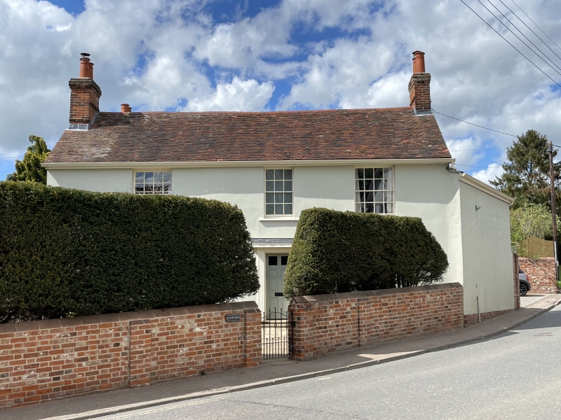
Entry Name: Junipers
Listing Date: 9 February 1978
Grade: II
Source: Historic England
Source ID: 1036675
English Heritage Legacy ID: 277893
ID on this website: 101036675
Location: Bures, Babergh, Suffolk, CO8
County: Suffolk
District: Babergh
Civil Parish: Bures St. Mary
Built-Up Area: Bures
Traditional County: Suffolk
Lieutenancy Area (Ceremonial County): Suffolk
Church of England Parish: Bures St Mary
Church of England Diocese: St.Edmundsbury and Ipswich
Tagged with: Building
HIGH STREET
1.
5377 (North-West Side)
Bures St Mary
Junipers
TL 9034 26/96
II GV
2.
An early C19 timber-framed and plastered house, brick faced on the front,
plastered. 2 storeys. 3 window range, double-hung sashes with glazing
bars, in plain reveals. A central doorway has panelled pilasters and
a cornice hood. Roof tiled, with end chimney stacks.
Listing NGR: TL9084834236
External links are from the relevant listing authority and, where applicable, Wikidata. Wikidata IDs may be related buildings as well as this specific building. If you want to add or update a link, you will need to do so by editing the Wikidata entry.


Other nearby listed buildings
